Jovsa
Jovsa
Jump to navigation
Jump to search
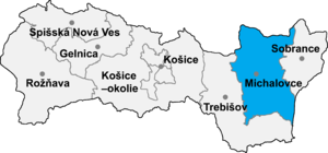
Michalovce District in the Kosice Region
Jovsa is a village and municipality in Michalovce District in the Kosice Region of eastern Slovakia.
Contents
1 History
2 Geography
3 Ethnicity
4 Culture
5 Genealogical resources
6 See also
7 External links
History[edit]
In historical records the village was first mentioned in 1418.
Geography[edit]
The village lies at an altitude of 138 metres and covers an area of 18.464 km².
It has a population of about 835 people.
Ethnicity[edit]
The population is about 99% Slovak in ethnicity.
Culture[edit]
The village has a small public library, a post office, a football pitch and a food store.
Genealogical resources[edit]
The records for genealogical research are available at the state archive "Statny Archiv in Presov, Slovakia"
- Greek Catholic church records (births/marriages/deaths): 1767-1914 (parish A)
See also[edit]
- List of municipalities and towns in Slovakia
External links[edit]
- https://web.archive.org/web/20071027094149/http://www.statistics.sk/mosmis/eng/run.html
Surnames of living people in Jovsa
Municipalities of Michalovce District | ||
|---|---|---|
| ||
Coordinates: 48°50′N 22°06′E / 48.833°N 22.100°E / 48.833; 22.100
This Michalovce District geography article is a stub. You can help Wikipedia by expanding it. |
Categories:
- Villages and municipalities in Michalovce District
- Michalovce District geography stubs
(window.RLQ=window.RLQ||).push(function(){mw.config.set({"wgPageParseReport":{"limitreport":{"cputime":"0.096","walltime":"0.148","ppvisitednodes":{"value":212,"limit":1000000},"ppgeneratednodes":{"value":0,"limit":1500000},"postexpandincludesize":{"value":14552,"limit":2097152},"templateargumentsize":{"value":103,"limit":2097152},"expansiondepth":{"value":12,"limit":40},"expensivefunctioncount":{"value":0,"limit":500},"unstrip-depth":{"value":0,"limit":20},"unstrip-size":{"value":0,"limit":5000000},"entityaccesscount":{"value":1,"limit":400},"timingprofile":["100.00% 100.367 1 -total"," 45.56% 45.725 1 Template:Michalovce_District"," 42.08% 42.233 1 Template:Navbox"," 38.02% 38.159 1 Template:Coord"," 16.26% 16.316 1 Template:Michalovce-geo-stub"," 15.87% 15.932 1 Template:Flagicon"," 13.86% 13.915 1 Template:Asbox"," 6.99% 7.014 1 Template:Country_data_Slovakia"," 5.39% 5.405 1 Template:Yesno-no"," 3.16% 3.171 1 Template:Flagicon/core"]},"scribunto":{"limitreport-timeusage":{"value":"0.035","limit":"10.000"},"limitreport-memusage":{"value":1214754,"limit":52428800}},"cachereport":{"origin":"mw1267","timestamp":"20190225023125","ttl":2073600,"transientcontent":false}}});});{"@context":"https://schema.org","@type":"Article","name":"Jovsa","url":"https://en.wikipedia.org/wiki/Jovsa","sameAs":"http://www.wikidata.org/entity/Q1074176","mainEntity":"http://www.wikidata.org/entity/Q1074176","author":{"@type":"Organization","name":"Contributors to Wikimedia projects"},"publisher":{"@type":"Organization","name":"Wikimedia Foundation, Inc.","logo":{"@type":"ImageObject","url":"https://www.wikimedia.org/static/images/wmf-hor-googpub.png"}},"datePublished":"2006-09-17T19:26:13Z","dateModified":"2017-04-28T11:01:05Z","image":"https://upload.wikimedia.org/wikipedia/commons/d/d6/Okres_michalovce.png","headline":"municipality of Slovakia"}(window.RLQ=window.RLQ||).push(function(){mw.config.set({"wgBackendResponseTime":119,"wgHostname":"mw1271"});});


