Autonomous administrative divisions of India
Autonomous administrative divisions of India
Jump to navigation
Jump to search

There were several autonomous administrative divisions of India to which the central government has given varying degrees of autonomy within the state legislature. The establishment and functions of most of these autonomous councils are based on the sixth schedule to the Constitution of India.[1]
Contents
1 In Assam
1.1 Bodoland Territorial Council
1.2 North Cachar Hills Autonomous District Council
1.3 Karbi Anglong Autonomous District Council
1.4 Others
2 In Manipur
2.1 Sadar Hills Autonomous District Council
2.2 Others
3 In Jammu and Kashmir
3.1 Ladakh Autonomous Hill Development Council, Kargil
3.2 Ladakh Autonomous Hill Development Council, Leh
4 In Meghalaya
4.1 Garo Hills Autonomous District Council
4.2 Jaintia Hills Autonomous District Council
4.3 Khasi Hills Autonomous District Council
5 In Mizoram
5.1 Chakma Autonomous District Council
5.2 Lai Autonomous District Council
5.3 Mara Autonomous District Council
6 In Tripura
6.1 Tripura Tribal Areas Autonomous District Council
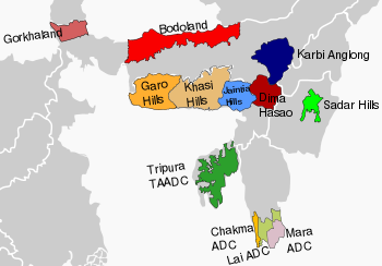
7 In West Bengal
7.1 Gorkhaland Territorial Administration
8 De facto autonomous
8.1 North Sentinel Island
9 See also
10 References
11 External links
In Assam[edit]
In Assam there are 3 Autonomous Councils under Sixth-Schedule of the Indian Constitution.
The 3 Autonomous Councils are:
Bodoland Territorial Council[edit]
The Bodoland Territorial Council (BTC) has legislative, administrative, executive and financial powers over 40 policy areas in the Bodoland Territorial Areas Districts comprising 4 Administrative Districts as- Udalguri, Baksa, Chirang, Kokrajhar comprising various protected tribal belts and blocks in Assam and 40 Elected Representatives to the BTC Legislative Assembly and provisions for 6 Nominated Members to be nominated by the Governor of Assam from the unrepresented communities in the BTCLA through direct election in the districts of Assam. It was established in 2003 following a peace agreement between the Government of India and Bodo Liberation Tigers and is functioning since 2003 under the provision of the Amended Sixth Schedule of the Constitution of India. The first Chief Executive Member of the BTC was Hagrama Mohilary. Its predecessor body Bodoland Autonomous Council was functional with lesser power.
Its headquarters is at Kokrajhar Town in Kokrajhar district.
North Cachar Hills Autonomous District Council[edit]
The North Cachar Hills Autonomous District Council (NCHAC) is an autonomous council constituted under the provisions of the Sixth Schedule of the Constitution of India to administer the district and to develop the hill people.
Its headquarter is Haflong in Dima Hasao district.
Karbi Anglong Autonomous District Council[edit]
The Karbi Anglong Autonomous District Council, East Karbi Anglong (KAADC) is an autonomous council in the district constituted under the provision of the Sixth Schedule of the Constitution of India for the development of Karbi people.
Its headquarter is Diphu in East Karbi Anglong district.[2]
Others[edit]
This section needs expansion. You can help by adding to it. (May 2018) |
- Deori Autonomous Council
- Mising Autonomous Council
- Rabha Hasong Autonomous Council
- Sonowal Kachari Autonomous Council
- Thengal Kachari Autonomous Council
- Tiwa Autonomous Council
In Manipur[edit]
Sadar Hills Autonomous District Council[edit]
The Sadar Hills Autonomous District Council (SHADC) covers Saikul Subdivision, Saitu Subdivision and Sadar Hills West Subdivision in Senapati District of Manipur. It is one of the six autonomous district councils in Manipur.
Others[edit]
This section needs expansion. You can help by adding to it. (May 2018) |
- Chandel Autonomous District Council
- Churachandpur Autonomous District Council
- Senapati Autonomous District Council
- Tamenglong Autonomous District Council
- Ukhrul Autonomous District Council
In Jammu and Kashmir[edit]
Ladakh Autonomous Hill Development Council, Kargil[edit]
Kargil is a district of Ladakh, Kashmir, India. Kargil lies near the Line of Control facing Pakistan-administered Kashmir's Gilgit-Baltistan to the west, and Kashmir valley to the south. Following demands of Ladakhi people to make the district a new Indian union territory because of its religious and cultural differences with Kashmir. The government of India formed the Ladakh Autonomous Hill Development Council (LAHDC), which governs the area with limited autonomy.
Ladakh Autonomous Hill Development Council, Leh[edit]
Leh is one of the two districts of Ladakh. Following widespread agitations to make it a Union Territory of India due to the cultural and linguistic differences with Kashmir the government of India formed the Ladakh Autonomous Hill Development Council (LAHDC), which governs this area with limited political autonomy. The first elections for the LAHDC were held in the year 1995.
In Meghalaya[edit]
Garo Hills Autonomous District Council[edit]
The Garo Hills Autonomous District Council (GHADC) is constituted for the development of Garo people and covers East Garo Hills district, West Garo Hills district, South Garo Hills, North Garo Hills district and South West Garo Hills district. It has headquarter in Tura.
Jaintia Hills Autonomous District Council[edit]
The Jaintia Hills Autonomous District Council (JHADC) is constituted for the development of Jaintia people. It has headquarter in Jowai and covers the Jaintia Hills district.
Khasi Hills Autonomous District Council[edit]
The Khasi Hills Autonomous District Council (KHADC) is constituted for the development of Khasi people covers West Khasi Hills district, East Khasi Hills district and Ri Bhoi district, It has headquarter in Shillong.
In Mizoram[edit]
Chakma Autonomous District Council[edit]
Chakma Autonomous District Council (CADC) is an autonomous council for the Chakma people living in the south-western part of Mizoram.
Lai Autonomous District Council[edit]
Lai Autonomous District Council (LADC) is an autonomous council for the Lai people in the South-eastern part of Mizoram.
Mara Autonomous District Council[edit]
Mara Autonomous District Council (MADC) is an autonomous council for the Mara people living in the Southern part of Mizoram.
In Tripura[edit]
Tripura Tribal Areas Autonomous District Council[edit]
The Tripura Tribal Areas Autonomous District Council (TTAADC) is an independent council administering the tribal areas of the state of Tripura. Its council and assembly are situated in Khumulwng, a town 20 km outside Agartala, the state capital.
In West Bengal[edit]
Gorkhaland Territorial Administration[edit]
Gorkhaland Territorial Administration (GTA) is a semi-autonomous administrative body for the Darjeeling hills in West Bengal, India. The GTA replaced the Darjeeling Gorkha Hill Council, which was formed in 1988 and administered the Darjeeling hills for 23 years.[3] GTA presently has three hill subdivisions Darjeeling, Kalimpong, and Kurseong and some areas of Siliguri subdivision under its authority. It has headquarter in Darjeeling.[4]
De facto autonomous[edit]
North Sentinel Island[edit]
North Sentinel Island is situated in the island chain of the Andaman and Nicobar Islands which is a union territory of India. It is home to the Sentinelese people, who are some of the world's last uncontacted peoples. They reject any contact with other people and are among the last people to remain virtually untouched by modern civilization. There has never been any treaty with the people of the island nor any record of a physical occupation.
The local government (Andaman and Nicobar Islands) has stated [5] that they have no intention to interfere with the Sentinelese's lifestyle or habitat. Although the island is likely to have suffered seriously from the effects of the December 2004 tsunami, the survival of the Sentinelese was confirmed when, some days after the event, an Indian government helicopter observed several of them, who shot arrows at the hovering aircraft to repel it.
Although this has not been done with any formal treaty, the official policy of minimal interference has ensured that they have de facto autonomy and sovereignty over their island under the framework of the Indian and local governments.[6]
See also[edit]
- States and territories of India
- List of autonomous areas by country
References[edit]
^ [Articles 244(2) and 275(1)] Archived 2008-12-03 at the Wayback Machine. Constitution of India.
^ http://mdoner.gov.in/node/752
^ "Gorkhaland Territorial Administration Agreement signed". Outlook. July 18, 2011. Archived from the original on 3 June 2012. Retrieved 16 March 2012..mw-parser-output cite.citation{font-style:inherit}.mw-parser-output .citation q{quotes:"""""""'""'"}.mw-parser-output .citation .cs1-lock-free a{background:url("//upload.wikimedia.org/wikipedia/commons/thumb/6/65/Lock-green.svg/9px-Lock-green.svg.png")no-repeat;background-position:right .1em center}.mw-parser-output .citation .cs1-lock-limited a,.mw-parser-output .citation .cs1-lock-registration a{background:url("//upload.wikimedia.org/wikipedia/commons/thumb/d/d6/Lock-gray-alt-2.svg/9px-Lock-gray-alt-2.svg.png")no-repeat;background-position:right .1em center}.mw-parser-output .citation .cs1-lock-subscription a{background:url("//upload.wikimedia.org/wikipedia/commons/thumb/a/aa/Lock-red-alt-2.svg/9px-Lock-red-alt-2.svg.png")no-repeat;background-position:right .1em center}.mw-parser-output .cs1-subscription,.mw-parser-output .cs1-registration{color:#555}.mw-parser-output .cs1-subscription span,.mw-parser-output .cs1-registration span{border-bottom:1px dotted;cursor:help}.mw-parser-output .cs1-ws-icon a{background:url("//upload.wikimedia.org/wikipedia/commons/thumb/4/4c/Wikisource-logo.svg/12px-Wikisource-logo.svg.png")no-repeat;background-position:right .1em center}.mw-parser-output code.cs1-code{color:inherit;background:inherit;border:inherit;padding:inherit}.mw-parser-output .cs1-hidden-error{display:none;font-size:100%}.mw-parser-output .cs1-visible-error{font-size:100%}.mw-parser-output .cs1-maint{display:none;color:#33aa33;margin-left:0.3em}.mw-parser-output .cs1-subscription,.mw-parser-output .cs1-registration,.mw-parser-output .cs1-format{font-size:95%}.mw-parser-output .cs1-kern-left,.mw-parser-output .cs1-kern-wl-left{padding-left:0.2em}.mw-parser-output .cs1-kern-right,.mw-parser-output .cs1-kern-wl-right{padding-right:0.2em}
^ "Pact signed for Gorkhaland Territorial Administration". The Hindu. July 18, 2011. Retrieved 16 March 2012.
^ The Sentineli Archived March 2, 2009, at the Wayback Machine.
^ Administration in India's Andaman and Nicobar Islands has finally decided upon a policy of minimal interference
External links[edit]
| |||||||||||||||||||||
| |||||||||||||||||||||
| |||||||||||||||||||||
| |||||||||||||||||||||
| |||||||||||||||||||||
Proposed states and territories of India | ||
|---|---|---|
| Proposed states |
|  |
| Proposed territories |
| |
Current states and territories | ||
Categories:
- Subdivisions of India
- Autonomous regions of India
(window.RLQ=window.RLQ||).push(function(){mw.config.set({"wgPageParseReport":{"limitreport":{"cputime":"0.400","walltime":"0.535","ppvisitednodes":{"value":1556,"limit":1000000},"ppgeneratednodes":{"value":0,"limit":1500000},"postexpandincludesize":{"value":185663,"limit":2097152},"templateargumentsize":{"value":1537,"limit":2097152},"expansiondepth":{"value":10,"limit":40},"expensivefunctioncount":{"value":2,"limit":500},"unstrip-depth":{"value":1,"limit":20},"unstrip-size":{"value":7916,"limit":5000000},"entityaccesscount":{"value":0,"limit":400},"timingprofile":["100.00% 348.988 1 -total"," 33.38% 116.484 1 Template:Reflist"," 29.93% 104.448 1 Template:India_topics"," 28.65% 99.978 1 Template:Navbox_with_collapsible_groups"," 27.40% 95.609 10 Template:Navbox"," 23.41% 81.703 2 Template:Cite_web"," 15.62% 54.496 2 Template:Expand_section"," 13.49% 47.077 2 Template:Ambox"," 10.99% 38.353 14 Template:Main"," 5.37% 18.748 1 Template:Portal-inline"]},"scribunto":{"limitreport-timeusage":{"value":"0.164","limit":"10.000"},"limitreport-memusage":{"value":4272300,"limit":52428800},"limitreport-logs":"table#1 {n ["size"] = "tiny",n}n"},"cachereport":{"origin":"mw1333","timestamp":"20190304214250","ttl":2592000,"transientcontent":false}}});mw.config.set({"wgBackendResponseTime":103,"wgHostname":"mw1248"});});


