Northwood, New South Wales
Northwood, New South Wales
Jump to navigation
Jump to search
Northwood Sydney, New South Wales | |||||||||||||||
|---|---|---|---|---|---|---|---|---|---|---|---|---|---|---|---|
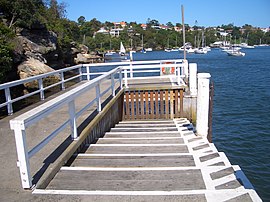
 Northwood Wharf | |||||||||||||||
| Population | 982 (2016 census)[1] | ||||||||||||||
| Postcode(s) | 2066 | ||||||||||||||
| Location | 8 km (5 mi) north-west of Sydney CBD | ||||||||||||||
| LGA(s) | Municipality of Lane Cove | ||||||||||||||
| State electorate(s) | Lane Cove | ||||||||||||||
| Federal Division(s) | North Sydney | ||||||||||||||
| |||||||||||||||
Northwood is a suburb on the Lower North Shore of Sydney, in the state of New South Wales, Australia 8 kilometres north-west of the Sydney central business district, in the local government area of the Municipality of Lane Cove. Northwood is on the northern side of the Lane Cove River between Woodford Bay and Gore Creek.
Contents
1 History
1.1 Heritage listings
2 Transport
3 Population
3.1 Demographics
3.2 Notable residents
4 References
History[edit]
Northwood is named after Northwood House, designed by Edmund Blacket (1817-1883) and built by Mrs Jane Davy in 1878. The name was chosen because it is descriptive of its location, a woodland area in the north. Mrs Davy also built a ferry at her own expense, so that her family could travel to the city by ferry.[2] For the early history of Northwood see John and Pam Ball, Exploring the early history of Northwood, Riverview, 2016.
Heritage listings[edit]
Northwood has a number of heritage-listed sites, including:
- 1 Private Road: Northwood House[3]
Transport[edit]
The nearest railway station is St Leonards and buses run frequently through the area. Northwood ferry wharf provides access to the Captain Cook Cruises Lane Cove River ferry service, which is popular for workers who commute to the CBD by ferry to Circular Quay.[4]
Population[edit]
Demographics[edit]
In the 2016 Australian Bureau of Statistics Census of Population and Housing, the population of Northwood stood at 982 people, 49.2% females and 50.8% males, with a median age of 45 years. 31.3% of the population was born overseas with England (5.5%), Malaysia (2.1%) and New Zealand (1.5%) the most common. The five strongest religious affiliations in the area were in descending order: Catholic (29.5%), no religion (28.2%), Anglican (19.4%), and Uniting Church (3.4%).[1]
Northwood's population is typically wealthy, with a median weekly household income of A$4,152, compared with A$1,438 in Australia. The most common types of occupation for employed persons were Professionals (48.6%), Managers (17.4%), and Clerical and Administrative Workers (12.1%). 91.0% of the suburbs occupied private dwellings were family households, and 9.0% were single (lone) person households.[1]
Notable residents[edit]
Northwood was the home of landscape artist Lloyd Rees for many years before his death in 1988.[5] Many of his later paintings are of the area.
Northwood was also home to portrait artist William Edwin Pidgeon, aka Bill Pidgeon and WEP, (1909 – 1981) who was an Australian painter. He won the Archibald Prize three times, 1958, 1961 and 1968.
References[edit]
^ abc Australian Bureau of Statistics (27 June 2017). "Northwood (State Suburb)". 2016 Census QuickStats. Retrieved 16 January 2018..mw-parser-output cite.citation{font-style:inherit}.mw-parser-output .citation q{quotes:"""""""'""'"}.mw-parser-output .citation .cs1-lock-free a{background:url("//upload.wikimedia.org/wikipedia/commons/thumb/6/65/Lock-green.svg/9px-Lock-green.svg.png")no-repeat;background-position:right .1em center}.mw-parser-output .citation .cs1-lock-limited a,.mw-parser-output .citation .cs1-lock-registration a{background:url("//upload.wikimedia.org/wikipedia/commons/thumb/d/d6/Lock-gray-alt-2.svg/9px-Lock-gray-alt-2.svg.png")no-repeat;background-position:right .1em center}.mw-parser-output .citation .cs1-lock-subscription a{background:url("//upload.wikimedia.org/wikipedia/commons/thumb/a/aa/Lock-red-alt-2.svg/9px-Lock-red-alt-2.svg.png")no-repeat;background-position:right .1em center}.mw-parser-output .cs1-subscription,.mw-parser-output .cs1-registration{color:#555}.mw-parser-output .cs1-subscription span,.mw-parser-output .cs1-registration span{border-bottom:1px dotted;cursor:help}.mw-parser-output .cs1-ws-icon a{background:url("//upload.wikimedia.org/wikipedia/commons/thumb/4/4c/Wikisource-logo.svg/12px-Wikisource-logo.svg.png")no-repeat;background-position:right .1em center}.mw-parser-output code.cs1-code{color:inherit;background:inherit;border:inherit;padding:inherit}.mw-parser-output .cs1-hidden-error{display:none;font-size:100%}.mw-parser-output .cs1-visible-error{font-size:100%}.mw-parser-output .cs1-maint{display:none;color:#33aa33;margin-left:0.3em}.mw-parser-output .cs1-subscription,.mw-parser-output .cs1-registration,.mw-parser-output .cs1-format{font-size:95%}.mw-parser-output .cs1-kern-left,.mw-parser-output .cs1-kern-wl-left{padding-left:0.2em}.mw-parser-output .cs1-kern-right,.mw-parser-output .cs1-kern-wl-right{padding-right:0.2em}

^ The Book of Sydney Suburbs, Compiled by Frances Pollen, Angus & Robertson Publishers, 1990, Published in Australia
ISBN 0-207-14495-8
^ "Northwood House & Cottage". New South Wales State Heritage Register. Office of Environment and Heritage. H00440. Retrieved 18 May 2018.
^ "Lane Cove Ferry timetable". Transport for NSW.
^ Commonwealth of Australia, It's an Honour: AC, 1987. Retrieved 24 March 2010.
Coordinates: 33°49′41″S 151°10′34″E / 33.82813°S 151.17619°E / -33.82813; 151.17619
"The Gardener's Gamble" by Helen Laidlaw
Categories:
- Suburbs of Sydney
- Lane Cove Council
(window.RLQ=window.RLQ||).push(function(){mw.config.set({"wgPageParseReport":{"limitreport":{"cputime":"0.300","walltime":"0.439","ppvisitednodes":{"value":2254,"limit":1000000},"ppgeneratednodes":{"value":0,"limit":1500000},"postexpandincludesize":{"value":34064,"limit":2097152},"templateargumentsize":{"value":2716,"limit":2097152},"expansiondepth":{"value":13,"limit":40},"expensivefunctioncount":{"value":4,"limit":500},"unstrip-depth":{"value":1,"limit":20},"unstrip-size":{"value":12464,"limit":5000000},"entityaccesscount":{"value":1,"limit":400},"timingprofile":["100.00% 404.784 1 -total"," 51.28% 207.561 1 Template:Reflist"," 30.04% 121.598 1 Template:Infobox_Australian_place"," 28.31% 114.602 1 Template:Census_2016_AUS"," 21.32% 86.304 3 Template:Cite_web"," 14.61% 59.124 1 Template:Infobox"," 11.55% 46.734 1 Template:Use_dmy_dates"," 9.78% 39.587 1 Template:ISBN"," 9.12% 36.920 1 Template:Short_description"," 7.65% 30.966 1 Template:Pagetype"]},"scribunto":{"limitreport-timeusage":{"value":"0.120","limit":"10.000"},"limitreport-memusage":{"value":3403562,"limit":52428800}},"cachereport":{"origin":"mw1331","timestamp":"20190319015743","ttl":2592000,"transientcontent":false}}});});{"@context":"https://schema.org","@type":"Article","name":"Northwood, New South Wales","url":"https://en.wikipedia.org/wiki/Northwood,_New_South_Wales","sameAs":"http://www.wikidata.org/entity/Q7060456","mainEntity":"http://www.wikidata.org/entity/Q7060456","author":{"@type":"Organization","name":"Contributors to Wikimedia projects"},"publisher":{"@type":"Organization","name":"Wikimedia Foundation, Inc.","logo":{"@type":"ImageObject","url":"https://www.wikimedia.org/static/images/wmf-hor-googpub.png"}},"datePublished":"2005-08-31T05:12:30Z","dateModified":"2019-02-08T06:03:09Z","image":"https://upload.wikimedia.org/wikipedia/commons/5/52/Northwood_Wharf.JPG","headline":"locality in New South Wales, Australia"}(window.RLQ=window.RLQ||).push(function(){mw.config.set({"wgBackendResponseTime":137,"wgHostname":"mw1242"});});