National Register of Historic Places listings in Washington County, Oregon
National Register of Historic Places listings in Washington County, Oregon
Jump to navigation
Jump to search

Location of Washington County in Oregon
This list presents the full set of buildings, structures, objects, sites, or districts designated on the National Register of Historic Places in Washington County, Oregon, and offers brief descriptive information about each of them. The National Register recognizes places of national, state, or local historic significance across the United States.[1] Out of over 90,000 National Register sites nationwide,[2]Oregon is home to over 2,000,[3] and 48 of those are found in Washington County.
This National Park Service list is complete through NPS recent listings posted February 15, 2019.[4]
Contents
1 Current listings
2 Former listings
3 Notes
4 See also
5 References
6 External links
Current listings[edit]
| [5] | Name on the Register | Image | Date listed[6] | Location | City or town | Description |
|---|---|---|---|---|---|---|
1 | Aloha Farmhouse | September 30, 2014 (#14000812) | 1080 SW 197th Avenue 45°30′43″N 122°52′45″W / 45.511997°N 122.879067°W / 45.511997; -122.879067 (Aloha Farmhouse) | Beaverton | Pietro Belluschi (1899–1994), Oregon's highest-regarded architect of the 20th century, lived in this then-isolated house from 1944 to 1948 during one of the most productive periods of his career. His renovations to the house reflect his ideas in the Northwest Regional style that he helped develop.[7] | |
2 | Beaverton Downtown Historic District |  | January 7, 1986 (#86000037) | Roughly bounded by SW Canyon Road and SW East, Washington, 2nd, and Watson Streets 45°29′15″N 122°48′20″W / 45.487377°N 122.805585°W / 45.487377; -122.805585 (Beaverton Downtown Historic District) | Beaverton | Beaverton's downtown commercial core remains largely intact as a pedestrian-oriented business district constructed along the street pattern from the city's earliest plats. Significant buildings include a handful from the city's first decades (1868–1920) and a larger number from the period of profound transformation between the world wars (1920–1940).[8] |
3 | Silas Jacob N. Beeks House | 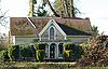 | June 14, 1984 (#84003100) | 3869 NW Martin Road 45°32′53″N 123°04′28″W / 45.54813°N 123.0744°W / 45.54813; -123.0744 (Silas Jacob N. Beeks House) | Forest Grove vicinity | |
4 | Stephen and Parthena M. Blank House |  | July 14, 1988 (#88001035) | 2117 A Street 45°31′17″N 123°06′49″W / 45.521513°N 123.113601°W / 45.521513; -123.113601 (Stephen and Parthena M. Blank House) | Forest Grove | Built c. 1858, this house is a prominent example of mid-19th century Greek Revival architecture in Forest Grove. It also exhibits a mix of frame construction techniques of the period. It was relocated a short distance in 1895, and may have been used as a stagecoach inn about that time.[9] |
5 | M. E. Blanton House |  | March 2, 1989 (#89000123) | 3980 SW 170th Avenue 45°29′28″N 122°51′05″W / 45.490976°N 122.851420°W / 45.490976; -122.851420 (M. E. Blanton House) | Aloha | This 1912 house, built during the early stages of the suburbanization of the area, is an unusually large and well-preserved example of the Craftsman architecture of the period. The design details, both exterior and interior, are exceptionally intact and richly express the Craftsman style.[10] |
6 | Clark Historic District |  | June 1, 2002 (#02000617) | Roughly bounded by 18th and 16th Avenues, A and Elm Streets 45°30′57″N 123°06′33″W / 45.51595°N 123.1092°W / 45.51595; -123.1092 (Clark Historic District) | Forest Grove | |
7 | Benjamin Cornelius Jr. House |  | July 14, 1988 (#88001034) | 2314 19th Avenue 45°31′05″N 123°06′21″W / 45.518059°N 123.105924°W / 45.518059; -123.105924 (Benjamin Cornelius Jr. House) | Forest Grove | This architecturally-important house was built c. 1873 by carpenter Harley McDonald, one of the first settlers to offer architectural services in Oregon, and is one of only two houses designed by McDonald remaining in Forest Grove.[a] Its Italianate form and Gothic details are highly distinctive in the local area.[11] |
8 | Harry A. Crosley House |  | September 9, 1993 (#93000919) | 2125 A Street 45°31′17″N 123°06′50″W / 45.52134°N 123.1138°W / 45.52134; -123.1138 (Harry A. Crosley House) | Forest Grove | |
9 | Doriot–Rider Log House |  | June 25, 2008 (#08000554) | 14850 SW 132nd Terrace 45°24′46″N 122°48′44″W / 45.41285278°N 122.8122083°W / 45.41285278; -122.8122083 (Doriot–Rider Log House) | Tigard | |
10 | Dundee Lodge |  | June 6, 1985 (#85001186) | South Road 45°27′34″N 123°11′57″W / 45.4594°N 123.1991°W / 45.4594; -123.1991 (Dundee Lodge) | Gaston vicinity | |
11 | Augustus Fanno Farmhouse | 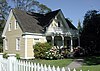 | April 5, 1984 (#84003103) | 8405 SW Creekside Place[12] 45°27′32″N 122°47′35″W / 45.458872°N 122.793167°W / 45.458872; -122.793167 (Augustus Fanno Farmhouse) | Beaverton | After emigrating across the Oregon Trail in 1846, Augustus Fanno settled this land claim — the twelfth claim filed at the Oregon City Land Office and the first in what is now Washington County. Fanno built the New England-style farmhouse with neoclassical details in 1859. The farm continued in productive operation until the 1940s, and the family occupied the house until the 1970s.[12] |
12 | Adam and Johanna Feldman House |  | February 11, 1993 (#93000013) | 8808 SW Rambler Lane 45°28′03″N 122°46′03″W / 45.46748°N 122.7675°W / 45.46748; -122.7675 (Adam and Johanna Feldman House) | Portland | |
13 | First Church of Christ Scientist | 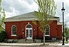 | January 21, 1994 (#93001505) | 1904 Pacific Avenue 45°31′11″N 123°06′49″W / 45.51966°N 123.1136°W / 45.51966; -123.1136 (First Church of Christ Scientist) | Forest Grove | |
14 | Imbrie Farm |  | February 15, 1977 (#77001117) | 4045 NE Cornelius Pass Road 45°32′57″N 122°54′02″W / 45.54919°N 122.9005°W / 45.54919; -122.9005 (Imbrie Farm) | Hillsboro | This former farm with buildings dating to 1855 includes an Italian Villa style home, an eight-sided barn, a shed, and several other out-buildings.[13] In 1986, the McMenamins chain bought the farm and converted it into the Cornelius Pass Roadhouse brewpub, which added Imbrie Hall constructed from timbers from Henry Weinhard's Brewery.[14] |
15 | Belle Ainsworth Jenkins Estate | 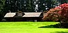 | November 28, 1978 (#78002327) | 8005 SW Grabhorn Road[12] 45°27′37″N 122°53′29″W / 45.460264°N 122.891372°W / 45.460264; -122.891372 (Belle Ainsworth Jenkins Estate) | Beaverton | Ralph and Belle Jenkins began construction on this 68-acre (28 ha) estate in 1912 as an escape from the city. They included fine equestrian facilities, as well as gardens, a greenhouse, an ornamental pool, a tea house, a carriage house, and a water tower. After the Jenkinses died the property changed hands several times, and was finally acquired as a public park in 1976.[12] |
16 | Zula Linklater House |  | August 1, 1984 (#84003108) | 230 NE 2nd Avenue 45°31′28″N 122°59′16″W / 45.52436°N 122.9879°W / 45.52436; -122.9879 (Zula Linklater House) | Hillsboro | This Mediterranean style office building in downtown was oringally a residence. Completed in 1923, it was converted into office space in 1984. The structure is built of concrete, wood, and stucco.[15] |
17 | Isaac Macrum House |  | August 28, 1998 (#98001120) | 2225 12th Avenue 45°30′39″N 123°06′29″W / 45.51076°N 123.108°W / 45.51076; -123.108 (Isaac Macrum House) | Forest Grove | |
18 | Manning–Kamna Farm |  | October 10, 2007 (#07001077) | 29375 Evergreen Road 45°33′02″N 122°58′45″W / 45.550536°N 122.979067°W / 45.550536; -122.979067 (Manning–Kamna Farm) | Hillsboro | The oldest of ten buildings on this farm is the cross-wing western farmhouse that was completed in 1883. Other buildings include a two-story barn, a privy, a woodshed, and a chicken coop, amongst other structures. The farm was settled in the 1850s, with the newest building a garage completed in the 1920s.[16] |
19 | Andrew Jackson and Sarah Jane Masters House |  | September 17, 2015 (#15000615) | 20650 SW Kinnaman Road 45°29′20″N 122°53′23″W / 45.488805°N 122.889701°W / 45.488805; -122.889701 (Andrew Jackson and Sarah Jane Masters House) | Aloha | |
20 | Malcolm McDonald House |  | January 14, 2015 (#14001160) | 7250 Northeast Birch Street 45°31′39″N 122°54′17″W / 45.527398°N 122.904675°W / 45.527398; -122.904675 (Malcolm McDonald House) | Hillsboro | |
21 | C. W. Mertz Rental House #2 |  | August 10, 2005 (#05000852) | 1933 16th Avenue 45°30′52″N 123°06′48″W / 45.51456°N 123.1133°W / 45.51456; -123.1133 (C. W. Mertz Rental House #2) | Forest Grove | |
22 | Thomas Michos House |  | October 17, 1991 (#91001552) | 4400 SW Scholls Ferry Road 45°29′19″N 122°44′46″W / 45.48872°N 122.746°W / 45.48872; -122.746 (Thomas Michos House) | Portland | |
23 | Oak Hills Historic District |  | July 10, 2013 (#13000482) | Roughly bounded by NW. West Union & Cornell Rds., NW 143rd Ave., Bethany Blvd. 45°32′20″N 122°49′57″W / 45.538931°N 122.832492°W / 45.538931; -122.832492 (Oak Hills Historic District) | Beaverton vicinity | |
24 | Old Scotch Church |  | November 5, 1974 (#74001723) | Scotch Church Road 45°34′22″N 122°59′40″W / 45.57281°N 122.9945°W / 45.57281; -122.9945 (Old Scotch Church) | Hillsboro | The Carpenter Gothic-style building was completed in 1878, and expanded in 1905. More expansion occurred in 1940, 1955, 1960, and 1984, including the first indoor restrooms in 1955. The cemetery on the grounds holds the graves of church members as well as local pioneer settlers of the Tualatin Plains, including Joseph Meek.[17] |
25 | Ole and Polly Oleson Farmhouse |  | February 22, 1991 (#91000140) | 5430 SW Ames Way 45°28′51″N 122°44′49″W / 45.48075°N 122.746847°W / 45.48075; -122.746847 (Ole and Polly Oleson Farmhouse) | Portland vicinity | |
26 | Painter's Woods Historic District |  | May 28, 2009 (#09000360) | Centered on 15th Avenue and Birch Street, including portions of 12th, 13th, and 14th Avenues, and Cedar and Douglas Streets 45°30′45″N 123°06′30″W / 45.512435°N 123.108198°W / 45.512435; -123.108198 (Painter's Woods Historic District) | Forest Grove | This residential area was the earliest modern subdivision addition to Forest Grove, and represents the town's transition from an agrarian community to a small-urban center. The district includes well-preserved examples of a broad range of architectural styles in currency between 1880 and 1948.[18] |
27 | John and Elsie Parsons House | 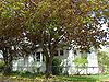 | August 10, 2005 (#05000853) | 1825 Mountain View Lane 45°31′04″N 123°04′33″W / 45.51785°N 123.0758°W / 45.51785; -123.0758 (John and Elsie Parsons House) | Forest Grove | |
28 | Harold Wass Ray House |  | January 21, 1994 (#93001504) | 5611 NE Elam Young Parkway 45°31′51″N 122°55′20″W / 45.530789°N 122.922297°W / 45.530789; -122.922297 (Harold Wass Ray House) | Hillsboro | Designed by Charles W. Ertz, the two-story home was completed in 1935. The Prairie School and Crafstman in style house sits on what was Hawthorn Farm, that later became one of Intel Corporation's campuses. The namesake had made his money from his cannery that became part of Birdseye Frozen Foods.[19] |
29 | Richard and Helen Rice House |  | November 29, 2006 (#06001096) | 26385 NW Groveland Drive 45°34′29″N 122°56′54″W / 45.57477°N 122.9482°W / 45.57477; -122.9482 (Richard and Helen Rice House) | Hillsboro | The 1952 home is the main part of the Rice Northwest Museum of Rocks and Minerals. It was the first ranch style home listed on the National Register of Historic Places in Oregon. The William F. Wayman-designed house was built of Arizona flagstone on the exterior and wood native to Oregon, including curly maple and myrtlewood. The 7,500 square feet (700 m2) home includes an elevator to the basement.[20] |
30 | Rice–Gates House |  | September 8, 1980 (#80003391) | 308 SE Walnut Street 45°31′03″N 122°59′10″W / 45.51755°N 122.986°W / 45.51755; -122.986 (Rice–Gates House) | Hillsboro | This Second Empire style residence has a mansard roof with diamond shaped shingles. The roof features a boxed cornice, Gable fronted dormers, and eaves with paired brackets. This 1890 structure has windows topped with an arch, plus include a pediment above each window. A former owner, Harry V. Gates, was a state legislator.[21] |
31 | James D. Robb House |  | July 14, 1988 (#88001033) | 2606 17th Avenue 45°30′57″N 123°06′03″W / 45.51576°N 123.1008°W / 45.51576; -123.1008 (James D. Robb House) | Forest Grove | |
32 | Schanen–Zolling House | 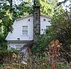 | December 10, 1985 (#85003340) | 6750 SW Oleson Road 45°28′17″N 122°44′58″W / 45.47131°N 122.7495°W / 45.47131; -122.7495 (Schanen–Zolling House) | Portland | |
33 | Edward Schulmerich House |  | February 28, 1991 (#91000050) | 614 E Main Street 45°31′21″N 122°58′49″W / 45.52257°N 122.9804°W / 45.52257; -122.9804 (Edward Schulmerich House) | Hillsboro | Completed in 1915, this two-story home in downtown Hillsboro was built for state senator Edward Schulmerich. He was a local merchant who was inspired by Craftsman architecture after a trip to Pasadena, California. The Airplane Bungalow-style house includes a wraparound porch. |
34 | Shaver–Bilyeu House |  | February 11, 1993 (#93000014) | 16445 SW 92nd Avenue 45°24′04″N 122°46′17″W / 45.401°N 122.7714°W / 45.401; -122.7714 (Shaver–Bilyeu House) | Tigard | |
35 | Albert S. Sholes House | 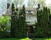 | September 2, 1982 (#82003755) | 1599 S Alpine Street 45°31′09″N 123°03′08″W / 45.51919°N 123.0523°W / 45.51919; -123.0523 (Albert S. Sholes House) | Cornelius | |
36 | Charles Shorey House |  | June 16, 1989 (#89000518) | 905 E Main Street 45°31′20″N 122°58′31″W / 45.52224°N 122.9754°W / 45.52224; -122.9754 (Charles Shorey House) | Hillsboro | Completed about 1908, the house is situated on land that was once part of a dairy farm. This Queen Anne style structure is a cross-shaped structure featuring the mixture of both a gambrel roof and a gable roof. The two-story home also has features of the Colonial Revival style.[22] |
37 | Shute–Meierjurgen Farmstead | July 6, 2018 (#100002647) | 4825 NE Starr Boulevard 45°33′19″N 122°56′14″W / 45.555237°N 122.937170°W / 45.555237; -122.937170 (Shute–Meierjurgen Farmstead) | Hillsboro vicinity | ||
38 | Alvin T. Smith House |  | November 8, 1974 (#74001721) | S Elm Street 45°30′16″N 123°06′15″W / 45.50454°N 123.1041°W / 45.50454; -123.1041 (Alvin T. Smith House) | Forest Grove vicinity | |
39 | John Sweek House |  | November 8, 1974 (#74001724) | 18815 SW Boones Ferry Road 45°23′03″N 122°45′54″W / 45.384233°N 122.764964°W / 45.384233; -122.764964 (John Sweek House) | Tualatin | |
40 | Dr. W. R. and Eunice Taylor House | 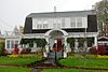 | August 10, 2005 (#05000851) | 2212 A Street 45°31′21″N 123°06′50″W / 45.52258°N 123.1139°W / 45.52258; -123.1139 (Dr. W. R. and Eunice Taylor House) | Forest Grove | |
41 | John W. Tigard House |  | July 20, 1979 (#79003739) | 10310 SW Canterbury Lane 45°24′53″N 122°47′00″W / 45.4146°N 122.7833°W / 45.4146; -122.7833 (John W. Tigard House) | Tigard | |
42 | Tualatin Academy | 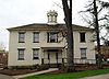 | February 12, 1974 (#74001722) | 2043 College Way 45°31′13″N 123°06′39″W / 45.520405°N 123.110773°W / 45.520405; -123.110773 (Tualatin Academy) | Forest Grove | This c. 1850 Colonial Revival building was the earliest home of what grew into Pacific University. Tracing its earliest roots to an orphanage operated by Tabitha Brown and Harvey L. Clark, Tualatin Academy received its official charter in 1849 as the first act of the Oregon Territorial Legislature. Renamed as Old College Hall in 1949,[23] it is the oldest educational building in the West.[24][25][26] |
43 | J. S. and Melinda Waggener Farmstead |  | July 25, 2003 (#03000693) | 34680 SW Firdale Road 45°26′37″N 123°02′29″W / 45.44359°N 123.0415°W / 45.44359; -123.0415 (J. S. and Melinda Waggener Farmstead) | Cornelius | |
44 | Walker Naylor Historic District |  | March 3, 2011 (#11000155) | Gayles Way, Covey Run Dr., A St., and 21st Ave. 45°31′23″N 123°06′56″W / 45.523056°N 123.115556°W / 45.523056; -123.115556 (Walker Naylor Historic District) | Forest Grove | |
45 | J. F. Watkins House |  | May 27, 1993 (#93000448) | 5419 SW Scholls Ferry Road 45°28′51″N 122°45′36″W / 45.48091°N 122.7601°W / 45.48091; -122.7601 (J. F. Watkins House) | Portland | |
46 | West Union Baptist Church |  | July 10, 1974 (#74001725) | West Union Road 45°34′25″N 122°54′24″W / 45.57367°N 122.9066°W / 45.57367; -122.9066 (West Union Baptist Church) | West Union | Built in 1853, this is the oldest Baptist church building in Oregon, and one of the earliest surviving pioneer churches in the state. The West Union congregation, organized in 1844, was the first Baptist church west of the Rocky Mountains.[27] |
47 | Woods and Caples General Store |  | December 2, 1985 (#85003028) | 2020 Main Street 45°31′12″N 123°06′44″W / 45.52002°N 123.1121°W / 45.52002; -123.1121 (Woods and Caples General Store) | Forest Grove | |
48 | John Quincy Adams and Elizabeth Young House |  | December 31, 2008 (#08001264) | 12050 NW Cornell Road 45°31′36″N 122°48′03″W / 45.526611°N 122.800867°W / 45.526611; -122.800867 (John Quincy Adams and Elizabeth Young House) | Portland vicinity | The Young family settled in this saltbox house in the 1860s when they acquired an interest in a nearby lumber mill, which became central to the local Cedar Mill community. In 1874, John Young opened Cedar Mill's first general store and post office in the house, which lasted until 1881. The house is the oldest remaining structure in Cedar Mill.[28] |
Former listings[edit]
| [5] | Name on the Register | Image | Date listed | Date removed | Location | City or town | Summary |
|---|---|---|---|---|---|---|---|
1 | Washington County Jail |  | July 31, 1986 (#86002090) | December 24, 2008 | 872 NE 28th Avenue (former) 45°31′36″N 122°48′03″W / 45.526611°N 122.800867°W / 45.526611; -122.800867 (Washington County Jail) | Hillsboro | Part or all of the jail building was moved to the Washington County Museum.[29] |
Notes[edit]
^ The other remaining home by McDonald in Forest Grove is the similar James D. Robb House.
See also[edit]
- National Register of Historic Places listings in Oregon
- Listings in neighboring counties: Clackamas, Columbia, Multnomah, Tillamook, Yamhill
- Historic preservation
- History of Oregon
- Lists of Oregon-related topics
References[edit]
^ Andrus, Patrick W.; Shrimpton, Rebecca H.; et al. (2002), How to Apply the National Register Criteria for Evaluation, National Register Bulletin (15), National Park Service, U.S. Department of the Interior, OCLC 39493977, archived from the original on April 6, 2014, retrieved June 20, 2014.mw-parser-output cite.citation{font-style:inherit}.mw-parser-output .citation q{quotes:"""""""'""'"}.mw-parser-output .citation .cs1-lock-free a{background:url("//upload.wikimedia.org/wikipedia/commons/thumb/6/65/Lock-green.svg/9px-Lock-green.svg.png")no-repeat;background-position:right .1em center}.mw-parser-output .citation .cs1-lock-limited a,.mw-parser-output .citation .cs1-lock-registration a{background:url("//upload.wikimedia.org/wikipedia/commons/thumb/d/d6/Lock-gray-alt-2.svg/9px-Lock-gray-alt-2.svg.png")no-repeat;background-position:right .1em center}.mw-parser-output .citation .cs1-lock-subscription a{background:url("//upload.wikimedia.org/wikipedia/commons/thumb/a/aa/Lock-red-alt-2.svg/9px-Lock-red-alt-2.svg.png")no-repeat;background-position:right .1em center}.mw-parser-output .cs1-subscription,.mw-parser-output .cs1-registration{color:#555}.mw-parser-output .cs1-subscription span,.mw-parser-output .cs1-registration span{border-bottom:1px dotted;cursor:help}.mw-parser-output .cs1-ws-icon a{background:url("//upload.wikimedia.org/wikipedia/commons/thumb/4/4c/Wikisource-logo.svg/12px-Wikisource-logo.svg.png")no-repeat;background-position:right .1em center}.mw-parser-output code.cs1-code{color:inherit;background:inherit;border:inherit;padding:inherit}.mw-parser-output .cs1-hidden-error{display:none;font-size:100%}.mw-parser-output .cs1-visible-error{font-size:100%}.mw-parser-output .cs1-maint{display:none;color:#33aa33;margin-left:0.3em}.mw-parser-output .cs1-subscription,.mw-parser-output .cs1-registration,.mw-parser-output .cs1-format{font-size:95%}.mw-parser-output .cs1-kern-left,.mw-parser-output .cs1-kern-wl-left{padding-left:0.2em}.mw-parser-output .cs1-kern-right,.mw-parser-output .cs1-kern-wl-right{padding-right:0.2em}.
^ National Park Service, National Register of Historic Places Program: Research, archived from the original on February 1, 2015, retrieved January 28, 2015.
^ Oregon Parks and Recreation Department, Oregon Historic Sites Database, retrieved August 6, 2015. Note that a simple count of National Register records in this database returns a slightly higher total than actual listings, due to duplicate records. A close reading of detailed query results is necessary to arrive at the precise count.
^ "National Register of Historic Places: Weekly List Actions". National Park Service, United States Department of the Interior. Retrieved on February 15, 2019.
^ ab Numbers represent an ordering by significant words. Various colorings, defined here, differentiate National Historic Landmarks and historic districts from other NRHP buildings, structures, sites or objects.
^ The eight-digit number below each date is the number assigned to each location in the National Register Information System database, which can be viewed by clicking the number.
^ Painter, Diana J.; Gunkel, Connie (May 16, 2014), National Register of Historic Places Registration Form: Aloha Farmhouse (PDF), retrieved December 14, 2017.
^ Demuth, Kimberly; Rees, Judith (March 14, 1985), National Register of Historic Places Inventory — Nomination Form: Beaverton Downtown Historic District (PDF), retrieved August 22, 2013
^ Haynes, Gladys; Gibbard, Mrs. Julian (August 1987), National Register of Historic Places Registration Form: Blank, Stephen and Parthena M., House (PDF), retrieved December 17, 2017.
^ Morrison, Jane (October 1988), National Register of Historic Places Registration Form: Blanton, M. E., House (PDF), retrieved December 21, 2017.
^ Waldorf, Mrs. Eric; Pearson, Kathleen (August 1987), National Register of Historic Places Registration Form: Cornelius, Benjamin, Jr., House (PDF), retrieved March 5, 2018.
^ abcd Tualatin Hills Park and Recreation District. "Historic Properties". Archived from the original on 2009-03-24. Retrieved 2009-04-24.
^ "Oregon Historic Site Record". Oregon Historic Preservation Office. Retrieved 23 December 2017.
^ "Cornelius Pass Roadhouse - McMenamins". www.mcmenamins.com. Retrieved 23 December 2017.
^ "Site Information: Zula Linklater House". Oregon Historic Sites Database. Oregon Parks & Recreation. Retrieved 23 December 2017.
^ "Site Information: Manning-Kamna Farm". Oregon Historic Sites Database. Oregon Department of Parks and Recreation. Retrieved 23 December 2017.
^ "Old Scotch Church: History". www.oldscotchchurch.org. Retrieved 23 December 2017.
^ Fitzgerald, Kimberli; Dennis, Michelle; Paulson, Sara (July 1, 2008), National Register of Historic Places Registration Form: Painter's Woods Historic District (PDF), retrieved November 14, 2015.
^ Fitzgerald, Kimberli; Deborah Raber (2009). Hillsboro. Arcadia Publishing. p. 100. Retrieved 21 January 2014.
^ Trappen, Michelle. “Close-in sun and fun: A stone's throw away”, The Oregonian, July 3, 2008, Metro West Neighbors, p. 10
^ "Site Information: Rice-Gates House". Oregon Historic Sites Database. Oregon Department of Parks and Recreation. Retrieved 23 December 2017.
^ "Site Information: Charles Shorey House". Oregon Historic Sites Database. Oregon Department of Parks & Recreation. Retrieved 23 December 2017.
^ Colby, Richard N. “Tour of time: An open house will make it easy to take in the county’s hidden treasures, historic and otherwise, in one swoop”, The Oregonian, April 23, 1998, West Zoner, p. 1.
^ Pacific University. "History of Pacific University". Archived from the original on December 21, 2017. Retrieved December 20, 2017.
^ Hartwig, Paul B. (November 1973), National Register of Historic Places Inventory — Nomination Form: Old College Hall (PDF), retrieved December 20, 2017.
^ O'Brien, Elizabeth J. (2003), National Register of Historic Places Registration Form: Old College Hall/Tualatin Academy (PDF), begins at PDF p. 7, retrieved December 20, 2017.
^ Hartwig, Paul (August 1973). "National Register of Historic Places Inventory–Nomination Form: West Union Baptist Church".
^ Carter, Liz; Fitzgerald, Kimberli (July 1, 2008), National Register of Historic Places Registration Form: Young, John Quincy Adams and Elizabeth, House (PDF), retrieved December 20, 2009.
^ Campbell (September 9, 2004). "West Zoner: The years have changed 'Doing Time'". The Oregonian. p. 2.
External links[edit]
- Oregon Parks and Recreation Department, National Register Program
- National Park Service, National Register of Historic Places site
 Media related to National Register of Historic Places in Washington County, Oregon at Wikimedia Commons
U.S. National Register of Historic Places in Oregon | ||
|---|---|---|
| Lists by county |
|   |
Portland lists |
| |
| Other lists |
| |
| ||
U.S. National Register of Historic Places | |
|---|---|
| Topics |
|
| Lists by state |
|
| Lists by insular areas |
|
| Lists by associated state |
|
| Other areas |
|
| |
Municipalities and communities of Washington County, Oregon, United States | ||
|---|---|---|
County seat: Hillsboro | ||
| Cities |
|  |
| CDPs |
| |
| Unincorporated communities |
| |
| Ghost towns |
| |
| Footnotes | ‡This populated place also has portions in an adjacent county or counties | |
Categories:
- National Register of Historic Places in Washington County, Oregon
- Lists of National Register of Historic Places in Oregon by county
(window.RLQ=window.RLQ||).push(function(){mw.config.set({"wgPageParseReport":{"limitreport":{"cputime":"1.232","walltime":"1.463","ppvisitednodes":{"value":21478,"limit":1000000},"ppgeneratednodes":{"value":0,"limit":1500000},"postexpandincludesize":{"value":450408,"limit":2097152},"templateargumentsize":{"value":38115,"limit":2097152},"expansiondepth":{"value":11,"limit":40},"expensivefunctioncount":{"value":4,"limit":500},"unstrip-depth":{"value":1,"limit":20},"unstrip-size":{"value":77322,"limit":5000000},"entityaccesscount":{"value":2,"limit":400},"timingprofile":["100.00% 935.672 1 -total"," 51.01% 477.252 49 Template:NRHP_row"," 29.21% 273.279 2 Template:Reflist"," 17.13% 160.301 12 Template:Citation"," 11.47% 107.338 1 Template:NRORextlinks"," 10.46% 97.869 97 Template:First_word"," 9.42% 88.104 49 Template:Coord"," 8.60% 80.512 50 Template:Designation/color"," 8.37% 78.284 50 Template:Dts"," 8.31% 77.760 58 Template:NRHP_color"]},"scribunto":{"limitreport-timeusage":{"value":"0.432","limit":"10.000"},"limitreport-memusage":{"value":8411197,"limit":52428800}},"cachereport":{"origin":"mw1273","timestamp":"20190222120727","ttl":2073600,"transientcontent":false}}});mw.config.set({"wgBackendResponseTime":92,"wgHostname":"mw1254"});});


