National Register of Historic Places listings in Northeast Portland, Oregon
National Register of Historic Places listings in Northeast Portland, Oregon
Jump to navigation
Jump to search
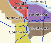
Locator map showing Portland's five quadrants. Click a quadrant to go to its National Register list.
This list presents the full set of buildings, structures, objects, sites, or districts designated on the National Register of Historic Places in Northeast Portland, Oregon, and offers brief descriptive information about each of them. The National Register recognizes places of national, state, or local historic significance across the United States.[1] Out of over 90,000 National Register sites nationwide,[2]Oregon is home to over 2,000,[3] and over one-fourth of those are found partially or wholly in Portland. While these sites are widely spread across all five of Portland's quadrants, heavy concentrations are found in the Downtown and Southwest Hills neighborhoods of the Southwest quadrant, and the Northwest District neighborhood of the Northwest quadrant.
Only historic places within the municipal boundaries of Portland are shown in this list and its companion lists for the other four quadrants. Some sites beyond city limits will appear in other lists showing "Portland" as a general locality, but are excluded here. Although Portland's legal boundaries extend into Clackamas and Washington counties, all of the city's National Register sites lie within Multnomah County.
This National Park Service list is complete through NPS recent listings posted February 15, 2019.[4]
Contents
1 Current listings
2 Former listings
3 See also
4 References
5 External links
Current listings[edit]
| [5] | Name on the Register | Image | Date listed[6] | Location | Description |
|---|---|---|---|---|---|
1 | Simon Abraham Duplex |  | August 5, 1999 (#99000945) | 522–530 NE San Rafael Street 45°32′13″N 122°39′36″W / 45.536899°N 122.660037°W / 45.536899; -122.660037 (Simon Abraham Duplex) | This 1890 Queen Anne house is one of extremely few duplexes in the Eliot neighborhood remaining from the late 19th/early 20th centuries. Its early ownership by German Americans and Scandinavian Americans testifies to the settlement by ethnic immigrants in this part of the former city of Albina.[7] |
2 | Alco Apartments |  | January 17, 2017 (#100000499) | 100–110 NE Martin Luther King Jr. Boulevard 45°31′26″N 122°39′41″W / 45.523803°N 122.661421°W / 45.523803; -122.661421 (Alco Apartments) | |
3 | Frederick Armbruster Cottage |  | February 16, 2001 (#01000130) | 502 NE Tillamook Street 45°32′16″N 122°39′38″W / 45.537664°N 122.660450°W / 45.537664; -122.660450 (Frederick Armbruster Cottage) | |
4 | Alfred J. and Georgia A. Armstrong House |  | September 14, 2002 (#02001017) | 509 NE Prescott Street 45°33′21″N 122°39′37″W / 45.555704°N 122.660242°W / 45.555704; -122.660242 (Alfred J. and Georgia A. Armstrong House) | |
5 | Thomas J. Autzen House |  | March 9, 1992 (#92000088) | 2425 NE Alameda Street 45°33′06″N 122°38′26″W / 45.551532°N 122.640417°W / 45.551532; -122.640417 (Thomas J. Autzen House) | William F. Willingham. "National Register of Historic Places listings in Northeast Portland, Oregon". The Oregon Encyclopedia..mw-parser-output cite.citation{font-style:inherit}.mw-parser-output .citation q{quotes:"""""""'""'"}.mw-parser-output .citation .cs1-lock-free a{background:url("//upload.wikimedia.org/wikipedia/commons/thumb/6/65/Lock-green.svg/9px-Lock-green.svg.png")no-repeat;background-position:right .1em center}.mw-parser-output .citation .cs1-lock-limited a,.mw-parser-output .citation .cs1-lock-registration a{background:url("//upload.wikimedia.org/wikipedia/commons/thumb/d/d6/Lock-gray-alt-2.svg/9px-Lock-gray-alt-2.svg.png")no-repeat;background-position:right .1em center}.mw-parser-output .citation .cs1-lock-subscription a{background:url("//upload.wikimedia.org/wikipedia/commons/thumb/a/aa/Lock-red-alt-2.svg/9px-Lock-red-alt-2.svg.png")no-repeat;background-position:right .1em center}.mw-parser-output .cs1-subscription,.mw-parser-output .cs1-registration{color:#555}.mw-parser-output .cs1-subscription span,.mw-parser-output .cs1-registration span{border-bottom:1px dotted;cursor:help}.mw-parser-output .cs1-ws-icon a{background:url("//upload.wikimedia.org/wikipedia/commons/thumb/4/4c/Wikisource-logo.svg/12px-Wikisource-logo.svg.png")no-repeat;background-position:right .1em center}.mw-parser-output code.cs1-code{color:inherit;background:inherit;border:inherit;padding:inherit}.mw-parser-output .cs1-hidden-error{display:none;font-size:100%}.mw-parser-output .cs1-visible-error{font-size:100%}.mw-parser-output .cs1-maint{display:none;color:#33aa33;margin-left:0.3em}.mw-parser-output .cs1-subscription,.mw-parser-output .cs1-registration,.mw-parser-output .cs1-format{font-size:95%}.mw-parser-output .cs1-kern-left,.mw-parser-output .cs1-kern-wl-left{padding-left:0.2em}.mw-parser-output .cs1-kern-right,.mw-parser-output .cs1-kern-wl-right{padding-right:0.2em} |
6 | Frank C. Barnes House |  | September 1, 1983 (#83002166) | 3533 NE Klickitat Street 45°32′49″N 122°37′39″W / 45.547064°N 122.627548°W / 45.547064; -122.627548 (Frank C. Barnes House) | |
7 | Barnhart–Wright House |  | June 13, 1997 (#97000582) | 1828 NE Knott Street 45°32′31″N 122°38′48″W / 45.541819°N 122.646681°W / 45.541819; -122.646681 (Barnhart–Wright House) | |
8 | Bay E, West Ankeny Car Barns |  | October 10, 1978 (#78002307) | 2706 NE Couch Street 45°31′24″N 122°38′17″W / 45.523202°N 122.637971°W / 45.523202; -122.637971 (Bay E, West Ankeny Car Barns) | |
9 | Boschke–Boyd House |  | February 25, 2005 (#05000094) | 2211 NE Thompson Street 45°32′21″N 122°38′34″W / 45.539215°N 122.642900°W / 45.539215; -122.642900 (Boschke–Boyd House) | |
10 | George W. and Hetty A. Bowers House |  | September 23, 2011 (#11000702) | 114 NE 22nd Avenue 45°31′26″N 122°38′36″W / 45.523889°N 122.643333°W / 45.523889; -122.643333 (George W. and Hetty A. Bowers House) | [8] |
11 | F. E. Bowman Apartments |  | June 16, 1989 (#89000511) | 1624–1636 NE Tillamook Street 45°32′14″N 122°38′55″W / 45.537201°N 122.648705°W / 45.537201; -122.648705 (F. E. Bowman Apartments) | |
12 | John and Ellen Bowman House |  | January 9, 2008 (#07001377) | 1719 NE Knott Street 45°32′33″N 122°38′53″W / 45.542394°N 122.647919°W / 45.542394; -122.647919 (John and Ellen Bowman House) | |
13 | Jennie Bramhall House |  | May 27, 1999 (#99000643) | 5125 NE Garfield Avenue 45°33′37″N 122°39′47″W / 45.560269°N 122.662962°W / 45.560269; -122.662962 (Jennie Bramhall House) | |
14 | Brick House Beautiful |  | January 27, 2012 (#11001063) | 4005 NE Davis Street 45°31′31″N 122°37′18″W / 45.525203°N 122.621781°W / 45.525203; -122.621781 (Brick House Beautiful) | |
15 | Burnside Bridge | November 14, 2012 (#12000931) | Willamette River at RM 12.7 45°31′23″N 122°40′03″W / 45.523037°N 122.667632°W / 45.523037; -122.667632 (Burnside Bridge) | Part of the Willamette River Highway Bridges of Portland, Oregon MPS | |
16 | George Earle Chamberlain House |  | June 19, 1991 (#91000815) | 1927 NE Tillamook Street 45°32′16″N 122°38′46″W / 45.537740°N 122.646031°W / 45.537740; -122.646031 (George Earle Chamberlain House) | |
17 | Clovelly Garden Apartments |  | May 19, 1983 (#83002169) | 6307–6319 NE Martin Luther King Jr. Boulevard 45°34′05″N 122°39′42″W / 45.567923°N 122.661675°W / 45.567923; -122.661675 (Clovelly Garden Apartments) | |
18 | Coleman–Scott House |  | November 8, 1985 (#85003504) | 2110 NE 16th Avenue 45°32′16″N 122°38′57″W / 45.537655°N 122.649077°W / 45.537655; -122.649077 (Coleman–Scott House) | |
19 | James C. and Mary A. Costello House |  | September 28, 2001 (#01001068) | 2043 NE Tillamook Street 45°32′16″N 122°38′41″W / 45.537645°N 122.644676°W / 45.537645; -122.644676 (James C. and Mary A. Costello House) | |
20 | Virgil and Beulah Crum House |  | August 5, 1999 (#99000944) | 4438 NE Alameda Street 45°32′35″N 122°37′05″W / 45.543018°N 122.618025°W / 45.543018; -122.618025 (Virgil and Beulah Crum House) | |
21 | Del Rey Apartments | February 20, 1991 (#91000040) | 2555 NE Glisan Street 45°31′37″N 122°38′22″W / 45.527005°N 122.639563°W / 45.527005; -122.639563 (Del Rey Apartments) | ||
22 | Henry B. Dickson House |  | August 1, 1997 (#97000849) | 2123 NE 21st Avenue 45°32′16″N 122°38′41″W / 45.537839°N 122.644622°W / 45.537839; -122.644622 (Henry B. Dickson House) | |
23 | Frank Silas Doernbecher House |  | March 14, 1978 (#78002311) | 2323 NE Tillamook Street 45°32′16″N 122°38′30″W / 45.537686°N 122.641672°W / 45.537686; -122.641672 (Frank Silas Doernbecher House) | |
24 | Emerson Apartments |  | January 27, 2000 (#99001714) | 5310 N Williams Avenue 45°33′43″N 122°40′00″W / 45.561858°N 122.666559°W / 45.561858; -122.666559 (Emerson Apartments) | |
25 | Raymond and Catherine Fisher House |  | March 2, 2006 (#06000096) | 1625 NE Marine Drive 45°36′02″N 122°38′54″W / 45.600489°N 122.648357°W / 45.600489; -122.648357 (Raymond and Catherine Fisher House) | |
26 | Gustav Freiwald House |  | May 27, 1993 (#93000454) | 1810 NE 15th Avenue 45°32′09″N 122°39′00″W / 45.535940°N 122.650107°W / 45.535940; -122.650107 (Gustav Freiwald House) | |
27 | Lewis T. Gilliland House |  | February 23, 1989 (#89000063) | 2229 NE Brazee Street 45°32′27″N 122°38′33″W / 45.540748°N 122.642521°W / 45.540748; -122.642521 (Lewis T. Gilliland House) | |
28 | Groat–Gates House |  | February 23, 1989 (#89000062) | 35 NE 22nd Avenue 45°31′24″N 122°38′38″W / 45.523453°N 122.643784°W / 45.523453; -122.643784 (Groat–Gates House) | |
29 | Hancock Street Fourplex |  | February 11, 1993 (#93000023) | 1414 NE Hancock Street 45°32′10″N 122°39′04″W / 45.536242°N 122.651032°W / 45.536242; -122.651032 (Hancock Street Fourplex) | |
30 | William A. Haseltine House |  | October 17, 1991 (#91001551) | 3231 NE U.S. Grant Place 45°32′17″N 122°37′56″W / 45.538040°N 122.632195°W / 45.538040; -122.632195 (William A. Haseltine House) | |
31 | Hibernian Hall |  | August 4, 2005 (#05000826) | 128 NE Russell Street 45°32′26″N 122°39′48″W / 45.540681°N 122.663453°W / 45.540681; -122.663453 (Hibernian Hall) | |
32 | Hollywood Theatre | 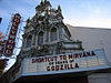 | September 1, 1983 (#83002172) | 4122 NE Sandy Boulevard 45°32′08″N 122°37′14″W / 45.535528°N 122.620639°W / 45.535528; -122.620639 (Hollywood Theatre) | |
33 | Irvington Bowman Apartments |  | September 14, 2002 (#02000968) | 1825–1835 NE 16th Avenue 45°32′10″N 122°38′59″W / 45.536243°N 122.649623°W / 45.536243; -122.649623 (Irvington Bowman Apartments) | |
34 | Irvington Historic District |  | October 22, 2010 (#10000850) | Roughly bounded by NE Fremont Street, NE Broadway, and NE 7th and 27th Avenues 45°32′31″N 122°38′54″W / 45.541944°N 122.648333°W / 45.541944; -122.648333 (Irvington Historic District) | Historic Residential Suburbs in the United States, 1830–1960 MPS[9] |
35 | Irvington Tennis Club |  | October 17, 1990 (#90001513) | 2131 NE Thompson Street 45°32′21″N 122°38′37″W / 45.539177°N 122.643610°W / 45.539177; -122.643610 (Irvington Tennis Club) | |
36 | Jantzen Knitting Mills Company Building | June 24, 1991 (#91000812) | 1935 NE Glisan Street 45°31′38″N 122°38′46″W / 45.527113°N 122.646018°W / 45.527113; -122.646018 (Jantzen Knitting Mills Company Building) | ||
37 | Oliver and Margaret Jeffrey House |  | September 21, 2005 (#05001059) | 3033 NE Bryce Street 45°33′06″N 122°38′04″W / 45.551566°N 122.634363°W / 45.551566; -122.634363 (Oliver and Margaret Jeffrey House) | |
38 | Jensen Investment Company Building |  | August 5, 1999 (#99000941) | 2500–2522 NE Martin Luther King Jr. Boulevard 45°32′26″N 122°39′41″W / 45.540647°N 122.661278°W / 45.540647; -122.661278 (Jensen Investment Company Building) | |
39 | Charles E. Johnson Building |  | August 5, 1999 (#99000949) | 442 NE Russell Street 45°32′28″N 122°39′38″W / 45.541101°N 122.660599°W / 45.541101; -122.660599 (Charles E. Johnson Building) | |
40 | H. C. Keck House – Mount Olivet Parsonage |  | October 10, 2002 (#02001124) | 53 NE Thompson Street 45°32′21″N 122°39′55″W / 45.539166°N 122.665178°W / 45.539166; -122.665178 (H. C. Keck House – Mount Olivet Parsonage) | |
41 | Edward H. and Bertha R. Keller House |  | November 20, 2009 (#09000943) | 3028 NE Alameda Street 45°32′59″N 122°38′06″W / 45.549621°N 122.634898°W / 45.549621; -122.634898 (Edward H. and Bertha R. Keller House) | This excellent example of an English cottage revival house was one of the few single-family homes designed by Portland architect Elmer E. Feig. Many of the themes and features of the Keller house foreshadowed his later work with large apartment buildings.[10] |
42 | John D. Kennedy Elementary School |  | November 22, 1995 (#88003472) | 5736 NE 33rd Avenue 45°33′52″N 122°37′49″W / 45.564468°N 122.630170°W / 45.564468; -122.630170 (John D. Kennedy Elementary School) | |
43 | Albertina Kerr Nursery |  | August 29, 1979 (#79002135) | 424 NE 22nd Avenue 45°31′34″N 122°38′35″W / 45.526127°N 122.643060°W / 45.526127; -122.643060 (Albertina Kerr Nursery) | |
44 | Henry C. Leutgert Building |  | May 27, 1999 (#99000642) | 2323–2329 NE Rodney Avenue 45°32′23″N 122°39′52″W / 45.539817°N 122.664329°W / 45.539817; -122.664329 (Henry C. Leutgert Building) | |
45 | Lindquist Apartment House |  | February 19, 1993 (#93000022) | 711 NE Randall Street 45°31′41″N 122°38′18″W / 45.528107°N 122.638472°W / 45.528107; -122.638472 (Lindquist Apartment House) | |
46 | Robert F. Lytle House |  | May 19, 1983 (#83002173) | 1914 NE 22nd Avenue 45°32′12″N 122°38′34″W / 45.536710°N 122.642663°W / 45.536710; -122.642663 (Robert F. Lytle House) | |
47 | Anna Lewis Mann Old People's Home |  | October 15, 1992 (#92001380) | 1021–1025 NE 33rd Avenue 45°31′50″N 122°37′53″W / 45.530475°N 122.631396°W / 45.530475; -122.631396 (Anna Lewis Mann Old People's Home) | |
48 | George W. and Hannah Martin – John B. and Minnie Hosford House |  | February 27, 2003 (#03000073) | 2004 NE 9th Avenue 45°32′13″N 122°39′22″W / 45.537016°N 122.656247°W / 45.537016; -122.656247 (George W. and Hannah Martin – John B. and Minnie Hosford House) | |
49 | McAvinney Fourplex |  | February 6, 2006 (#05001147) | 2004 NE 17th Avenue 45°32′13″N 122°38′53″W / 45.537013°N 122.648134°W / 45.537013; -122.648134 (McAvinney Fourplex) | |
50 | Fred O. Miller House |  | January 18, 2006 (#05001540) | 2329 NE Thompson Street 45°32′21″N 122°38′29″W / 45.539195°N 122.641524°W / 45.539195; -122.641524 (Fred O. Miller House) | |
51 | Henry B. Miller House |  | October 30, 1989 (#89001865) | 2439 NE 21st Avenue 45°32′25″N 122°38′41″W / 45.540324°N 122.644699°W / 45.540324; -122.644699 (Henry B. Miller House) | |
52 | Nicolai–Cake–Olson House |  | August 8, 2001 (#01000828) | 1903 NE Hancock Street 45°32′12″N 122°38′47″W / 45.536652°N 122.646470°W / 45.536652; -122.646470 (Nicolai–Cake–Olson House) | |
53 | Northwest Fence and Wire Works |  | August 4, 2005 (#05000828) | 400–418 NE 11th Avenue 45°31′34″N 122°39′15″W / 45.525975°N 122.654238°W / 45.525975; -122.654238 (Northwest Fence and Wire Works) | |
54 | Northwestern Electric Company – Alberta Substation |  | March 5, 1998 (#98000207) | 2701–2717 NE Alberta Street 45°33′33″N 122°38′16″W / 45.559205°N 122.637709°W / 45.559205; -122.637709 (Northwestern Electric Company – Alberta Substation) | |
55 | Olsen and Weygandt Building |  | February 11, 1993 (#93000024) | 1421–1441 NE Broadway 45°32′07″N 122°39′03″W / 45.535253°N 122.650764°W / 45.535253; -122.650764 (Olsen and Weygandt Building) | |
56 | August Olson House |  | June 3, 1996 (#96000624) | 2509 NE 18th Avenue 45°32′27″N 122°38′51″W / 45.540732°N 122.647637°W / 45.540732; -122.647637 (August Olson House) | |
57 | Oregon State Bank Building |  | July 12, 2000 (#00000801) | 4200 NE Sandy Boulevard 45°32′10″N 122°37′11″W / 45.535982°N 122.619715°W / 45.535982; -122.619715 (Oregon State Bank Building) | |
58 | Page and Son Apartments |  | March 8, 1989 (#89000113) | 723–737 E Burnside Street 45°31′23″N 122°39′28″W / 45.523125°N 122.657916°W / 45.523125; -122.657916 (Page and Son Apartments) | |
59 | Parkview Apartments |  | March 6, 1992 (#92000085) | 1760 NE Irving Street 45°31′38″N 122°38′55″W / 45.527283°N 122.648491°W / 45.527283; -122.648491 (Parkview Apartments) | |
60 | Pearson Mortuary |  | December 13, 2007 (#07001261) | 301 NE Knott Street 45°32′32″N 122°39′47″W / 45.542094°N 122.662964°W / 45.542094; -122.662964 (Pearson Mortuary) | |
61 | Pipes Family House |  | December 23, 2005 (#05001150) | 3045 NE 9th Avenue 45°32′42″N 122°39′25″W / 45.544983°N 122.656847°W / 45.544983; -122.656847 (Pipes Family House) | |
62 | John E. G. Povey House |  | August 28, 1998 (#98001121) | 1312 NE Tillamook Street 45°32′14″N 122°39′07″W / 45.537260°N 122.652080°W / 45.537260; -122.652080 (John E. G. Povey House) | |
63 | Ira F. Powers Warehouse and Factory |  | August 31, 2011 (#11000625) | 123 NE 3rd Avenue 45°31′26″N 122°39′47″W / 45.523953°N 122.662987°W / 45.523953; -122.662987 (Ira F. Powers Warehouse and Factory) | This 1925 building is one of the last remnants of two important phases in Portland's economic history: the city's once-prominent furniture manufacturing and distribution industry, and worker housing for the war industries of the World War II era.[11] |
64 | Thomas Prince House |  | October 23, 1986 (#86002911) | 2903 NE Alameda Street 45°33′02″N 122°38′08″W / 45.550497°N 122.635643°W / 45.550497; -122.635643 (Thomas Prince House) | |
65 | Reed–Wells House |  | August 20, 2004 (#04000878) | 2168 NE Multnomah Street 45°31′53″N 122°38′36″W / 45.531259°N 122.643412°W / 45.531259; -122.643412 (Reed–Wells House) | |
66 | Rocky Butte Scenic Drive Historic District |  | October 17, 1991 (#91001550) | Along NE Rocky Butte Road with parts of NE Fremont Street and NE 92nd Avenue 45°32′48″N 122°33′57″W / 45.546714°N 122.565941°W / 45.546714; -122.565941 (Rocky Butte Scenic Drive Historic District) | |
67 | Roome–Stearns House |  | March 9, 1992 (#92000087) | 2146 NE 12th Avenue 45°32′17″N 122°39′11″W / 45.538178°N 122.653174°W / 45.538178; -122.653174 (Roome–Stearns House) | |
68 | Rose City Golf Clubhouse |  | October 31, 2012 (#12000900) | 2200 NE 71st Avenue 45°32′17″N 122°35′24″W / 45.538084°N 122.589979°W / 45.538084; -122.589979 (Rose City Golf Clubhouse) | |
69 | Alfred C. and Nettie Ruby House |  | January 26, 2006 (#05001559) | 211 NE César E. Chávez Boulevard 45°31′31″N 122°37′24″W / 45.525205°N 122.623411°W / 45.525205; -122.623411 (Alfred C. and Nettie Ruby House) | |
70 | Rutherford House |  | August 5, 2015 (#14001076) | 833 NE Shaver Street 45°33′08″N 122°39′25″W / 45.552239°N 122.656852°W / 45.552239; -122.656852 (Rutherford House) | |
71 | Salerno Apartments |  | January 28, 1994 (#93001563) | 2325 NE Flanders Street 45°31′33″N 122°38′31″W / 45.525960°N 122.641834°W / 45.525960; -122.641834 (Salerno Apartments) | |
72 | Senate Court Apartments |  | February 21, 1997 (#97000129) | 203–223 NE 22nd Avenue 45°31′28″N 122°38′38″W / 45.524570°N 122.643919°W / 45.524570; -122.643919 (Senate Court Apartments) | |
73 | Seufert House |  | October 10, 2006 (#06000944) | 1511 NE Knott Street 45°32′32″N 122°39′00″W / 45.542330°N 122.650067°W / 45.542330; -122.650067 (Seufert House) | Also known as the Mautz–Seufert House. |
74 | Fred A., May, and Ann Shogren House |  | July 3, 1989 (#89000517) | 400 NE 62nd Avenue 45°31′33″N 122°35′57″W / 45.525810°N 122.599051°W / 45.525810; -122.599051 (Fred A., May, and Ann Shogren House) | |
75 | Spies–Robinson House |  | June 13, 1997 (#97000583) | 2424 NE 17th Avenue 45°32′24″N 122°38′53″W / 45.540071°N 122.648065°W / 45.540071; -122.648065 (Spies–Robinson House) | |
76 | Tannler–Armstrong House |  | September 6, 2002 (#02000948) | 4420 NE Alameda Street 45°32′36″N 122°37′05″W / 45.543332°N 122.618120°W / 45.543332; -122.618120 (Tannler–Armstrong House) | |
77 | Thompson Court Apartments |  | February 21, 1997 (#97000121) | 2304–2314 NE 11th Avenue 45°32′21″N 122°39′15″W / 45.539157°N 122.654270°W / 45.539157; -122.654270 (Thompson Court Apartments) | |
78 | Fred Tunturi House |  | October 3, 1996 (#96001072) | 5115 NE Garfield Avenue 45°33′36″N 122°39′47″W / 45.560066°N 122.662940°W / 45.560066; -122.662940 (Fred Tunturi House) | |
79 | Frederick Turner Fourplex |  | March 5, 1992 (#92000135) | 1430 NE 22nd Avenue 45°32′00″N 122°38′34″W / 45.533370°N 122.642700°W / 45.533370; -122.642700 (Frederick Turner Fourplex) | |
80 | Lewis and Elizabeth Van Vleet House |  | September 3, 2001 (#01000937) | 202 NE Graham Street 45°32′33″N 122°39′48″W / 45.542622°N 122.663254°W / 45.542622; -122.663254 (Lewis and Elizabeth Van Vleet House) | |
81 | Louis and Elizabeth Woerner House |  | June 1, 2005 (#05000516) | 2815 NE Alameda Street 45°33′02″N 122°38′16″W / 45.550432°N 122.637714°W / 45.550432; -122.637714 (Louis and Elizabeth Woerner House) | Arts and Crafts. Woerner House (1922)[12] |
82 | Zimmerman–Rudeen House |  | June 19, 1991 (#91000811) | 3425 NE Beakey Street 45°32′51″N 122°37′42″W / 45.547414°N 122.628459°W / 45.547414; -122.628459 (Zimmerman–Rudeen House) | Prairie School house (1913) designed by George A. Eastman.[13] |
Former listings[edit]
| [5] | Name on the Register | Image | Date listed | Date removed | Location | Summary |
|---|---|---|---|---|---|---|
1 | Charles Looff 20-Sweep Menagerie Carousel | 1987 (#87001379) | May 27, 1998 | NE Holladay Street at NE 8th Avenue 45°31′47″N 122°39′27″W / 45.529654°N 122.657395°W / 45.529654; -122.657395 (Charles Looff 20-Sweep Menagerie Carousel) | Now located in San Diego, California | |
2 | Shriners Hospital for Crippled Children |  | October 30, 1989 (#89001869) | June 8, 2011 | 8200 NE Sandy Boulevard 45°33′09″N 122°34′43″W / 45.55246°N 122.5786°W / 45.55246; -122.5786 (Shriners Hospital for Crippled Children) | Building deconstructed in 2004, site redeveloped as Columbia Knoll housing complex.[14] |
3 | Trinity Lutheran Church and School |  | May 7, 1980 (#80003377) | January 4, 2008 | 106 NE Ivy Street 45°32′50″N 122°39′50″W / 45.547253°N 122.663807°W / 45.547253; -122.663807 (Trinity Lutheran Church and School) | Destroyed by fire. |
See also[edit]
- National Register of Historic Places listings in Oregon
- National Register of Historic Places listings in Multnomah County, Oregon
- Listings in neighboring counties: Clackamas, Clark, Columbia, Hood River, Skamania, Washington
- Historic preservation
- History of Portland, Oregon
- Lists of Oregon-related topics
References[edit]
^ Andrus, Patrick W.; Shrimpton, Rebecca H.; et al. (2002), How to Apply the National Register Criteria for Evaluation, National Register Bulletin (15), National Park Service, U.S. Department of the Interior, OCLC 39493977, archived from the original on April 6, 2014, retrieved June 20, 2014.
^ National Park Service, National Register of Historic Places Program: Research, archived from the original on February 1, 2015, retrieved January 28, 2015.
^ Oregon Parks and Recreation Department, Oregon Historic Sites Database, retrieved August 6, 2015. Note that a simple count of National Register records in this database returns a slightly higher total than actual listings, due to duplicate records. A close reading of detailed query results is necessary to arrive at the precise count.
^ "National Register of Historic Places: Weekly List Actions". National Park Service, United States Department of the Interior. Retrieved on February 15, 2019.
^ ab Numbers represent an ordering by significant words. Various colorings, defined here, differentiate National Historic Landmarks and historic districts from other NRHP buildings, structures, sites or objects.
^ The eight-digit number below each date is the number assigned to each location in the National Register Information System database, which can be viewed by clicking the number.
^ Roos, Roy E. (February 1999), National Register of Historic Places Registration Form: Abraham, Simon, Duplex (PDF), retrieved October 6, 2013.
^ Provost, Elizabeth; Line, William (February 2011), National Register of Historic Places Registration Form: Bowers, George W. and Hetty A., House (PDF), retrieved March 17, 2012.
^ National Park Service (October 29, 2010). "Weekly List of Actions Taken on Properties: 10/18/10 through 10/22/10". Retrieved October 29, 2010.
^ Roos, Roy E. (January 30, 2009), National Register of Historic Places Registration Form: Keller, Edward H. and Bertha R., House (PDF), retrieved December 6, 2014.
^ Tess, John M. (July 1, 2011), National Register of Historic Places Registration Form: Powers, Ira F., Warehouse and Factory (PDF), retrieved January 6, 2015.
^ [1] National Register Nomination Form, Woerner House. Matthew J. Hayes
^ "Zimmerman-Rudeen House". Building Oregon: Architecture of Oregon and the Pacific Northwest. University of Oregon. Archived from the original on July 20, 2011. Retrieved May 27, 2008.
^ Riegel, Rich (June 2, 2004). "DeConstruction Services goes to work". Daily Journal of Commerce. Retrieved June 20, 2011.
External links[edit]
- Oregon Parks and Recreation Department, National Register Program
- National Park Service, National Register of Historic Places site
 Media related to National Register of Historic Places in Portland, Oregon at Wikimedia Commons
U.S. National Register of Historic Places in Oregon | ||
|---|---|---|
| Lists by county |
|   |
Portland lists |
| |
| Other lists |
| |
| ||
U.S. National Register of Historic Places | |
|---|---|
| Topics |
|
| Lists by state |
|
| Lists by insular areas |
|
| Lists by associated state |
|
| Other areas |
|
| |
City of Portland, Oregon | ||
|---|---|---|
|  | |
| ||
| ||
| ||
Categories:
- Northeast Portland, Oregon
- Lists of National Register of Historic Places in Portland, Oregon
(window.RLQ=window.RLQ||).push(function(){mw.config.set({"wgPageParseReport":{"limitreport":{"cputime":"1.620","walltime":"1.984","ppvisitednodes":{"value":32689,"limit":1000000},"ppgeneratednodes":{"value":0,"limit":1500000},"postexpandincludesize":{"value":586033,"limit":2097152},"templateargumentsize":{"value":43242,"limit":2097152},"expansiondepth":{"value":11,"limit":40},"expensivefunctioncount":{"value":3,"limit":500},"unstrip-depth":{"value":1,"limit":20},"unstrip-size":{"value":40496,"limit":5000000},"entityaccesscount":{"value":2,"limit":400},"timingprofile":["100.00% 1114.654 1 -total"," 70.49% 785.754 85 Template:NRHP_row"," 14.84% 165.390 165 Template:First_word"," 12.92% 143.970 85 Template:Coord"," 12.85% 143.217 93 Template:NRHP_color"," 12.40% 138.244 1 Template:Reflist"," 12.32% 137.318 84 Template:Designation/color"," 11.99% 133.594 88 Template:Dts"," 9.01% 100.446 82 Template:NRHP_Focus"," 8.07% 89.925 1 Template:NRORextlinks"]},"scribunto":{"limitreport-timeusage":{"value":"0.491","limit":"10.000"},"limitreport-memusage":{"value":4492003,"limit":52428800}},"cachereport":{"origin":"mw1262","timestamp":"20190222120755","ttl":2073600,"transientcontent":false}}});mw.config.set({"wgBackendResponseTime":101,"wgHostname":"mw1249"});});


