Chinamans Hat Island
Chinamans Hat Island
| This is the current revision of this page, as edited by ZackBot(talk | contribs) at 18:58, 19 November 2018 (fixing deprecated params from Template:Infobox islands - ZackBot 12 - Approved). The present address (URL) is a permanent link to this version. |
Jump to navigation
Jump to search
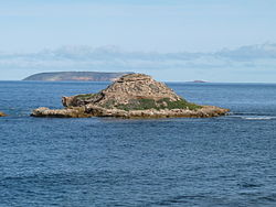 Chinamans Hat Island as viewed from the nearby coastline | |
 Chinamans Hat Island | |
| Geography | |
|---|---|
| Location | Investigator Strait |
| Coordinates | 35°17′20″S 136°55′05″E / 35.28876°S 136.91795°E / -35.28876; 136.91795Coordinates: 35°17′20″S 136°55′05″E / 35.28876°S 136.91795°E / -35.28876; 136.91795 |
| Administration | |
Australia | |
Chinamans Hat Island is an islet located off the south coast of Yorke Peninsula in Investigator Strait in South Australia about 2.4 kilometres (1.5 miles) south-west of Stenhouse Bay and within 350 metres (1,150 feet) of the shore. As of 2014, it is located within the Innes National Park.
Contents
1 Description
2 Formation, geology and oceanography
3 Flora and fauna
3.1 Flora
3.2 Fauna
4 Protected areas status
5 References
Description[edit]
Chinamans Hat Island is located about 350 metres (1,150 feet) from the shoreline and about 2.4 kilometres (1.5 miles) south-west of Stenhouse Bay. The islet is a remnant piece of cliff line which rises to a height of 11 metres (36 feet) and sits on an intertidal rock platform that joins the mainland at the west and extends past the island to the east. The islet is named due to the similarity of its shape to a conical Asian hat. Access is reported as being ‘best gained by small boat, taking care to avoid the shallow rocks and reefs in the surrounding waters.’[1]
The name ‘Chinamans Hat’ is also informally used for other features near the islet such as the small bay located between it and the mainland, the intertidal reef that connects it to the mainland and facilities on the mainland provided as part of the Innes National Park.[2]
Formation, geology and oceanography[edit]
Chinamans Hat Island was formed between 7500 and 8900 years ago after sea levels rose at the start of the Holocene thereby separating Yorke Peninsula from Kangaroo Island.[3]
Chinamans Hat Island is reported as being entirely composed of a Bridgewater Formation calcarenite rock with ‘distinct horizontal layers of hard calcrete’.[1][4]
The islet rises from a depth of 10 metres (33 feet).[5]
Flora and fauna[edit]
Flora[edit]
A survey conducted in 1996 found eleven species of plants including sea celery, marsh saltbush, round leaved pigface, ruby saltbush, grey samphire, nitre-bush, bower spinach and common iceplant.[1]
Fauna[edit]
As of 1996, vertebrate animals were represented by bird species such as little penguins, feral pigeons and sooty oystercatchers.[1]
Protected areas status[edit]
Chinamans Hat Island has been reported as being part of the Innes National Park by 1980.[6] Since 2012, the waters surrounding its shores are located in a sanctuary zone within the boundaries of the South Spencer Gulf Marine Park.[7]
References[edit]
^ abcd A. C. Robinson; P. Canty; T. Mooney; P. Rudduck (1996). "South Australia's offshore islands" (PDF). Australian Heritage Commission. pp. 285–286. Retrieved 13 December 2013..mw-parser-output cite.citation{font-style:inherit}.mw-parser-output .citation q{quotes:"""""""'""'"}.mw-parser-output .citation .cs1-lock-free a{background:url("//upload.wikimedia.org/wikipedia/commons/thumb/6/65/Lock-green.svg/9px-Lock-green.svg.png")no-repeat;background-position:right .1em center}.mw-parser-output .citation .cs1-lock-limited a,.mw-parser-output .citation .cs1-lock-registration a{background:url("//upload.wikimedia.org/wikipedia/commons/thumb/d/d6/Lock-gray-alt-2.svg/9px-Lock-gray-alt-2.svg.png")no-repeat;background-position:right .1em center}.mw-parser-output .citation .cs1-lock-subscription a{background:url("//upload.wikimedia.org/wikipedia/commons/thumb/a/aa/Lock-red-alt-2.svg/9px-Lock-red-alt-2.svg.png")no-repeat;background-position:right .1em center}.mw-parser-output .cs1-subscription,.mw-parser-output .cs1-registration{color:#555}.mw-parser-output .cs1-subscription span,.mw-parser-output .cs1-registration span{border-bottom:1px dotted;cursor:help}.mw-parser-output .cs1-ws-icon a{background:url("//upload.wikimedia.org/wikipedia/commons/thumb/4/4c/Wikisource-logo.svg/12px-Wikisource-logo.svg.png")no-repeat;background-position:right .1em center}.mw-parser-output code.cs1-code{color:inherit;background:inherit;border:inherit;padding:inherit}.mw-parser-output .cs1-hidden-error{display:none;font-size:100%}.mw-parser-output .cs1-visible-error{font-size:100%}.mw-parser-output .cs1-maint{display:none;color:#33aa33;margin-left:0.3em}.mw-parser-output .cs1-subscription,.mw-parser-output .cs1-registration,.mw-parser-output .cs1-format{font-size:95%}.mw-parser-output .cs1-kern-left,.mw-parser-output .cs1-kern-wl-left{padding-left:0.2em}.mw-parser-output .cs1-kern-right,.mw-parser-output .cs1-kern-wl-right{padding-right:0.2em}
^ "Innes National Park Management Plan" (PDF). Department of Environment, Water and Natural Resources. pp. 10, 14, 39 & 41. Retrieved 2 July 2014.
^ Robinson, A. C.; Armstrong, D. M. (eds.). A Biological Survey of Kangaroo Island, South Australia, 1989 & 1990 (PDF). Adelaide, SA: Heritage and Biodiversity Section, Department for Environment, Heritage and Aboriginal Affairs, South Australia. p. 26. ISBN 0 7308 5862 6. Retrieved 1 May 2014.
^ Fairclough, Martin C (December 2007). "KINGSCOTE Special 1:250 000 geological map". MESA Journal. Government of South Australia, DMITRE. 47: 28–31. ISSN 1326-3544. Retrieved 18 May 2014.
^ South Australia. Department of Marine and Harbors (1985), The Waters of South Australia a series of charts, sailing notes and coastal photographs, Dept. of Marine and Harbors, South Australia, pp. Chart 23, ISBN 978-0-7243-7603-2
^ "Innes National Park Management Plan" (PDF). Department of Environment, Water and Natural Resources. p. 10. Retrieved 2 July 2014.
^ "Marine Park 12, South Spencer Gulf" (PDF). Department of Environment Water and Natural Resources. 2012. Retrieved 2 July 2014.
Islands of South Australia | |||||||||
|---|---|---|---|---|---|---|---|---|---|
| West coast of Eyre Peninsula |
| ||||||||
| Spencer Gulf |
| ||||||||
| Investigator Strait |
| ||||||||
| Kangaroo Island |
| ||||||||
| Gulf St Vincent |
| ||||||||
| Backstairs Passage |
| ||||||||
Encounter Bay and adjoining waters |
| ||||||||
| South east coast |
| ||||||||
| Mainland |
| ||||||||
| |||||||||
Yorke Peninsula, South Australia | |||||||
|---|---|---|---|---|---|---|---|
| Major Townships |
| ||||||
| Minor Townships |
| ||||||
| Governance |
| ||||||
| Coastal features |
| ||||||
| Protected areas |
| ||||||
| Adjacent islands |
| ||||||
| Related and uncategorised |
| ||||||
| |||||||
Categories:
- Yorke Peninsula
- Islands of South Australia
- Uninhabited islands of Australia
- Investigator Strait
(window.RLQ=window.RLQ||).push(function(){mw.config.set({"wgPageParseReport":{"limitreport":{"cputime":"0.712","walltime":"0.895","ppvisitednodes":{"value":2931,"limit":1000000},"ppgeneratednodes":{"value":0,"limit":1500000},"postexpandincludesize":{"value":112319,"limit":2097152},"templateargumentsize":{"value":5341,"limit":2097152},"expansiondepth":{"value":14,"limit":40},"expensivefunctioncount":{"value":4,"limit":500},"unstrip-depth":{"value":1,"limit":20},"unstrip-size":{"value":22760,"limit":5000000},"entityaccesscount":{"value":2,"limit":400},"timingprofile":["100.00% 750.759 1 -total"," 38.43% 288.522 1 Template:Reflist"," 30.46% 228.656 1 Template:Infobox_islands"," 24.63% 184.897 4 Template:Cite_web"," 23.02% 172.789 1 Template:Infobox"," 10.19% 76.532 8 Template:Navbox"," 9.70% 72.833 6 Template:Convert"," 7.11% 53.386 1 Template:Location_map"," 6.50% 48.832 1 Template:Islands_of_South_Australia"," 6.25% 46.953 1 Template:Cite_journal"]},"scribunto":{"limitreport-timeusage":{"value":"0.370","limit":"10.000"},"limitreport-memusage":{"value":7007186,"limit":52428800}},"cachereport":{"origin":"mw1242","timestamp":"20190417174510","ttl":2592000,"transientcontent":false}}});mw.config.set({"wgBackendResponseTime":164,"wgHostname":"mw1244"});});


