File:Ile-de-France region location map.svg
File:Ile-de-France region location map.svg
Jump to navigation
Jump to search
- File
- File history
- File usage
- Global file usage
- Metadata

Size of this PNG preview of this SVG file: 742 × 600 pixels. Other resolutions: 297 × 240 pixels | 594 × 480 pixels | 951 × 768 pixels | 1,267 × 1,024 pixels | 1,651 × 1,334 pixels.
Original file (SVG file, nominally 1,651 × 1,334 pixels, file size: 944 KB)
| This is a file from the Wikimedia Commons. Information from its description page there is shown below. Commons is a freely licensed media file repository. You can help. |
Summary
| Camera location | View this and other nearby images on: OpenStreetMap - Google Earth |
|---|
| DescriptionIle-de-France region location map.svg | English: Blank administrative map of the region of Île-de-France, France, as in January 2015, for geo-location purpose, with distinct boundaries for regions, departments and arrondissements. Français : Carte administrative vierge de la région Île-de-France, France, telle qu'en janvier 2015, destinée à la géolocalisation, avec limite distincte des régions, départements et arrondissements. Estimated scale: 1:400,000 (precision: 100 m)
Geographic limits of the map:
| ||
| Date | January 2015 | ||
| Source | Own work
| ||
| Author | Eric Gaba (Sting - fr:Sting) | ||
| Permission (Reusing this file) |
| ||
| Other versions |
|

Licensing
Eric Gaba, Wikimedia Commons user Sting, the copyright holder of this work, hereby publishes it under the following license:
| This file is licensed under the Creative Commons Attribution-Share Alike 3.0 Unported license. | |
| Attribution: Eric Gaba, Wikimedia Commons user Sting | ||
https://creativecommons.org/licenses/by-sa/3.0 |
File history
Click on a date/time to view the file as it appeared at that time.
| Date/Time | Thumbnail | Dimensions | User | Comment | |
|---|---|---|---|---|---|
| current | 15:21, 12 February 2015 | 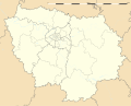 | 1,651 × 1,334 (944 KB) | Sting | Boundaries correction |
| 16:25, 22 January 2015 |  | 1,651 × 1,334 (945 KB) | Sting | Boundaries correction | |
| 14:03, 21 January 2015 |  | 1,651 × 1,334 (943 KB) | Sting | == {{int:filedesc}} == {{Location|48|40|30|N|02|30|00|E|scale:1000000}} {{Information |Description={{en|Blank administrative map of the region of Île-de-France, France, as in January 2015, for geo-location purpose, with distinct... |
File usage
More than 100 pages use this file.
The following list shows the first 100 pages that use this file only.
A full list is available.
- Antony, Hauts-de-Seine
- Argenteuil
- Arpajon
- Asnières-sur-Seine
- Athis-Mons
- Aubervilliers
- Aulnay-sous-Bois
- Bagneux, Hauts-de-Seine
- Bobigny
- Bois-Colombes
- Bondy
- Boulogne-Billancourt
- Bourg-la-Reine
- Boutigny-sur-Essonne
- Bures-sur-Yvette
- Cergy
- Champigny-sur-Marne
- Charenton-le-Pont
- Charles de Gaulle Airport
- Chaville
- Choisy-le-Roi
- Châtenay-Malabry
- Châtillon, Hauts-de-Seine
- Clamart
- Colombes
- Corbeil-Essonnes
- Courbevoie
- Croissy-sur-Seine
- Créteil
- Drancy
- Enghien-les-Bains
- Fontainebleau
- Fontenay-aux-Roses
- Garches
- Gare du Nord
- Gennevilliers
- Gif-sur-Yvette
- Gonesse
- Houdan
- Issy-les-Moulineaux
- Ivry-sur-Seine
- Jouy-le-Moutier
- Juvisy-sur-Orge
- La Ferté-Alais
- La Garenne-Colombes
- La Roche-Guyon
- Le Blanc-Mesnil
- Le Bourget
- Le Raincy
- Levallois-Perret
- Limours
- Mantes-la-Jolie
- Mantes-la-Ville
- Meaux
- Melun
- Meudon
- Milly-la-Forêt
- Montereau-Fault-Yonne
- Montreuil, Seine-Saint-Denis
- Montrouge
- Moret-sur-Loing
- Mézières-sur-Seine
- Nanterre
- Neuilly-sur-Seine
- Noisy-le-Grand
- Orly
- Orly Airport
- Palaiseau
- Pantin
- Paris Peace Conference, 1919
- Pierrefitte-sur-Seine
- Poissy
- Pontoise
- Provins
- Puteaux
- Rambouillet
- Rocquencourt
- Roissy-en-France
- Rosny-sous-Bois
- Rueil-Malmaison
- Rungis
- Saint-Cloud
- Saint-Cyr-l'École
- Saint-Germain-en-Laye
- Saint-Germain-lès-Arpajon
- Saint-Maur-des-Fossés
- Saint-Ouen, Seine-Saint-Denis
- Sarcelles
- Sartrouville
- Sevran
- Tournan-en-Brie
- Varennes-Jarcy
- Verrières-le-Buisson
- Versailles, Yvelines
- Villeneuve-Saint-Georges
- Villiers-sur-Orge
- Vincennes
- Vitry-sur-Seine
- Épinay-sur-Orge
- Épinay-sur-Seine
Global file usage
The following other wikis use this file:
- Usage on als.wikipedia.org
- Vorlage:Positionskarte Frankreich Île-de-France
- Usage on bh.wikipedia.org
- पैरिस
- टेम्पलेट:Infobox French commune
- टेम्पलेट:Infobox French commune/doc
- Usage on bs.wikipedia.org
- Evropsko prvenstvo u nogometu 2016.
- Šablon:Smještaj nogometnih reprezentacija na EP 2016.
- Šablon:Lokacijska karta Île-de-France
- Usage on cy.wikipedia.org
- Nodyn:Location map France Île-de-France
- Usage on de.wikipedia.org
- Benutzer:Wahrerwattwurm/Trainingsgelände
- Vertrag von Versailles (1756)
- Wikipedia:Kartenwerkstatt/Positionskarten/Europa
- Fußball-Europameisterschaft 2016
- Liste der Länderspiele der französischen Fußballnationalmannschaft der Frauen
- Diskussion:Fußball-Europameisterschaft 2016/Archiv/1
- Vorlage:Positionskarte Frankreich Île-de-France
- Wikipedia:Kartenwerkstatt/Archiv/2016-09
- Pont de Choisy
- Division 1 Féminine 2017/18
- Division 1 Féminine 2018/19
- Usage on el.wikipedia.org
- Πρότυπο:Location map Ιλ-ντε-Φρανς
- Usage on es.wikipedia.org
- París
- Aeropuerto de París-Orly
- Arboretum Vilmorin
- Boulogne-Billancourt
- Arboretum de la Vallée-aux-Loups
- Anexo:Patrimonio de la Humanidad en Francia
- Eurocopa 2016
- Parque botánico de Launay
- Arboreto de Grignon
- Plantilla:Mapa de localización de Isla de Francia
- Castillo de Courson (y Las Plantas de Courson)
- Castillo de Saint-Germain-en-Laye
- Arboretum municipal de Verrières-le-Buisson
- Parque Raymond-Sibille
- Arboretum de La Roche-Guyon
- Castillo y arboreto de Segrez
- Sainte-Chapelle de Vincennes
- Catedral de Meaux
- Palacio de Maisons-Laffitte
- Castillo de Écouen
- Catedral de Nuestra Señora (Créteil)
- Catedral de la Resurrección y San Corbiniano (Évry)
- Catedral de Santa Genoveva y San Mauricio (Nanterre)
- Catedral de San Luis (Versalles)
- Catedral de San Malo (Pontoise)
- Catedral de San Luis y San Nicolás (Choisy-le-Roi)
- Catedral de San Exuperio (Corbeil-Essonnes)
- Museo Bossuet
- Castillo de Sceaux
- Abadía de Jouarre
View more global usage of this file.
Metadata
(window.RLQ=window.RLQ||).push(function(){mw.config.set({"wgBackendResponseTime":258,"wgHostname":"mw1268"});});


