Canton of La Ferté-sous-Jouarre
Canton of La Ferté-sous-Jouarre
Jump to navigation
Jump to search
La Ferté-sous-Jouarre | |
|---|---|
Canton | |
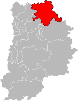
 Location of canton of La Ferté-sous-Jouarre in the department of Seine-et-Marne | |
| Country | France |
| Region | Île-de-France |
| Department | Seine-et-Marne |
| Arrondissement | Meaux |
| Seat | La Ferté-sous-Jouarre |
| Communes | 47 |
| Area ¹ | |
| • Total | 491.05 km2 (189.60 sq mi) |
| Population (2012) | |
| • Total | 59,696 |
| • Density | 120/km2 (310/sq mi) |
| Cantonal code | 77 06 |
| ¹ French Land Register data, which exclude estuaries, and lakes, ponds, and glaciers larger than 1 km2. | |
The canton of La Ferté-sous-Jouarre is a French administrative division, located in the arrondissement of Meaux, in the Seine-et-Marne département (Île-de-France région).
Contents
1 Demographics
2 Composition
3 See also
4 Sources
5 References
Demographics[edit]
| 1962 | 1968 | 1975 | 1982 | 1990 | 1999 | 2006 |
|---|---|---|---|---|---|---|
| 24,634 | 26,636 | |||||
From the year 1962 onward: population without double counting | ||||||
Composition[edit]
At the French canton reorganisation which came into effect in March 2015, the canton was expanded from 19 to 47 communes:[1]
- Armentières-en-Brie
- Bassevelle
- Bussières
- Chamigny
- Changis-sur-Marne
- Citry
- Cocherel
- Congis-sur-Thérouanne
- Coulombs-en-Valois
- Crouy-sur-Ourcq
- Dhuisy
- Douy-la-Ramée
- Étrépilly
- La Ferté-sous-Jouarre
- Fublaines
- Germigny-l'Évêque
- Germigny-sous-Coulombs
- Isles-les-Meldeuses
- Jaignes
- Jouarre
- Lizy-sur-Ourcq
- Luzancy
- Marcilly
- Mary-sur-Marne
- May-en-Multien
- Méry-sur-Marne
- Montceaux-lès-Meaux
- Nanteuil-lès-Meaux
- Nanteuil-sur-Marne
- Ocquerre
- Pierre-Levée
- Le Plessis-Placy
- Poincy
- Puisieux
- Reuil-en-Brie
- Saâcy-sur-Marne
- Sainte-Aulde
- Saint-Jean-les-Deux-Jumeaux
- Sammeron
- Sept-Sorts
- Signy-Signets
- Tancrou
- Trilport
- Trocy-en-Multien
- Ussy-sur-Marne
- Vendrest
- Vincy-Manœuvre
See also[edit]
- Cantons of the Seine-et-Marne department
- Communes of the Seine-et-Marne department
Sources[edit]
INSEE (in French)
Union des Maires de Seine-et-Marne (in French)
References[edit]
^ Décret n° 2014-186 du 18 février 2014 portant délimitation des cantons dans le département de Seine-et-Marne
Coordinates: 48°57′04″N 3°08′34″E / 48.95111°N 3.14278°E / 48.95111; 3.14278
This article related to a Seine-et-Marne location is a stub. You can help Wikipedia by expanding it. |
Categories:
- Cantons of Seine-et-Marne
- Seine-et-Marne geography stubs
(window.RLQ=window.RLQ||).push(function(){mw.config.set({"wgPageParseReport":{"limitreport":{"cputime":"0.428","walltime":"0.539","ppvisitednodes":{"value":3443,"limit":1000000},"ppgeneratednodes":{"value":0,"limit":1500000},"postexpandincludesize":{"value":29117,"limit":2097152},"templateargumentsize":{"value":2896,"limit":2097152},"expansiondepth":{"value":26,"limit":40},"expensivefunctioncount":{"value":0,"limit":500},"unstrip-depth":{"value":0,"limit":20},"unstrip-size":{"value":526,"limit":5000000},"entityaccesscount":{"value":1,"limit":400},"timingprofile":["100.00% 476.032 1 -total"," 48.90% 232.793 1 Template:Infobox_French_canton"," 47.76% 227.352 1 Template:Infobox_settlement"," 32.51% 154.773 2 Template:Fr_icon"," 32.07% 152.676 1 Template:Link_language"," 22.56% 107.373 1 Template:Infobox"," 7.78% 37.017 1 Template:Coord"," 5.71% 27.170 1 Template:Infobox_settlement/areadisp"," 4.93% 23.467 2 Template:Infobox_settlement/metric"," 4.39% 20.898 1 Template:Cantons_of_Seine-et-Marne"]},"scribunto":{"limitreport-timeusage":{"value":"0.209","limit":"10.000"},"limitreport-memusage":{"value":10115400,"limit":52428800}},"cachereport":{"origin":"mw1322","timestamp":"20190224062758","ttl":2073600,"transientcontent":false}}});mw.config.set({"wgBackendResponseTime":644,"wgHostname":"mw1322"});});